Overview
WHAT I DO AT CSM
- Teaching: Structural geology and tectonics; geological field data acquisition and interpretation, surface and underground geological mapping; geology and resources of SW England / Cornwall; supervision of BSc / MSci / MSc projects. [more]
- Research + Knowledge Transfer: SW England is a resource-rich region and superb natural laboratory. My research addresses all aspects of regional geological evolution, i.e. Variscan / post-Variscan tectonics and its influence on structural geology and sedimentation, magmatism, mineralisation and mineral / geothermal resources, as well as coastal landsliding. I'm engaged in collaborative research and knowledge transfer that contributes to the regional exploration and production activities of companies operating in the minerals and geothermal sectors [more]
- Administration: CSM Undergraduate Admissions Tutor
ACADEMIC QUALIFICATIONS
- BA (Hons) Geology, 1986 (University of Oxford)
- PhD Geology, 1992 (University of Keele)
EMPLOYMENT HISTORY
- 1990-1993 Camborne School of Mines, Lecturer in Geology
- 1993-present University of Exeter, Lecturer/Senior Lecturer/Associate Professor of Geology
AFFILIATIONS
- Member of the Ussher Society
- Member of the American Geophysical Union
EXTERNAL APPOINTMENT
-
External Examiner for undergraduate Geology programmes (BEES), University College Cork, Ireland 2020-24
EXTERNAL LINKS FOR RESEARCH OUTPUTS
Publications
Copyright Notice: Any articles made available for download are for personal use only. Any other use requires prior permission of the author and the copyright holder.
| 2024 | 2023 | 2022 | 2020 | 2019 | 2018 | 2017 | 2016 | 2015 | 2014 | 2013 | 2012 | 2011 | 2010 | 2009 | 2007 | 2006 | 2003 | 2002 | 2001 | 2000 | 1999 | 1998 | 1997 | 1996 | 1995 | 1994 | 1991 | 1990 | 1989 | 1988 |
2024
- Watts AB, Xu C, Searle MP, Jurkowski C, Shail RK. (2024) The Permian Cornubian granite batholith, SW England; Part 2: Gravity anomalies, structure, and state of isostasy, Geological Society of America Bulletin, DOI:10.1130/b37459.1. [PDF]
- Mackay‐Champion TC, Searle MP, Tapster S, Roberts NMW, Shail RK, Palin RM, Willment GH, Evans JT. (2024) Magmatic, Metamorphic and Structural History of the Variscan Lizard Ophiolite and Metamorphic Sole, Cornwall, UK, Tectonics, volume 43, no. 4, DOI:10.1029/2023tc008187. [PDF]
- Searle MP, Shail RK, Pownall JM, Jurkowski C, Watts AB, Robb LJ. (2024) The Permian Cornubian granite batholith, SW England; Part 1: Field, structural, and petrological constraints, GSA Bulletin, DOI:10.1130/b37457.1. [PDF]
- Turan A, Brown C, Shail R, Sass I. (2024) Probabilistic Assessment of Deep Geothermal Resources and Their Development in Cornwall and Devon, United Kingdom, DOI:10.2139/ssrn.4729082.
- Putzolu F, Seltmann R, Dolgopolova A, Armstrong RN, Shail RK, Spratt J, Buret Y, Broderick C, Brownscombe W. (2024) Influence of magmatic and magmatic-hydrothermal processes on the lithium endowment of micas in the Cornubian Batholith (SW England), Mineralium Deposita, DOI:10.1007/s00126-024-01248-5. [PDF]
2023
- Shail R, Simons B. (2023) The Cornubian Batholith: Post-Collisional Variscan Granites and Resources, Metallic Resources 1 Geodynamic Framework and Remarkable Examples in Europe, John Wiley & Sons, 143-219, DOI:10.1002/9781394264810. [PDF]
- Inskip NF, Harpers N, Shail R, Claes H, Hartog SD, Busch A. (2023) Reservoir properties of fault-related hydrothermally altered granites in Cornwall: Implications for geothermal energy prospectivity, DOI:10.22541/essoar.170110671.11387934/v1.
2022
- Shail R, Simons B. (2022) Le batholite de Cornouailles: granites et ressources post-collisionnels du varisque, Ressources Metalliques 1: Cadre géodynamique et exemples remarquables en Europe, ISTE, 139-216. [PDF]
- Yeomans CM, Claridge H, Hudson AJL, Shail RK, Willems C, Eyre M, Harker C. (2022) A single multi-scale and multi-sourced semi-automated lineament detection technique for detailed structural mapping with applications to geothermal energy exploration, Quarterly Journal of Engineering Geology and Hydrogeology, DOI:10.1144/qjegh2022-051. [PDF]
- Deady E, Moon C, Moore K, Goodenough KM, Shail RK. (2022) Bismuth: economic geology and value chains, Ore Geology Reviews, volume 143, article no. 104722, DOI:10.1016/j.oregeorev.2022.104722. [PDF]
2020
- Yeomans C, Claridge H, Hudson A, Shail R, Willems C, Eyre M, Harker C. (2020) A single multi-scale and multi-sourced semi-automated lineament detection technique for detailed structural mapping with applications to geothermal energy exploration, DOI:10.31223/x5r59c. [PDF]
- Yeomans C, Shail R, Eyre M. (2020) The importance of tectonic inheritance and reactivation in geothermal energy exploration for EGS resources in SW England, World Geothermal Congress, Reykjavik, Iceland, 26th Apr - 2nd May 2020, Proceedings World Geothermal Congress 2020.
- Bevins RE, Pirrie D, Ixer RA, O'Brien H, Pearson MP, Power MR, Shail RK. (2020) Constraining the provenance of the Stonehenge ‘Altar Stone’: Evidence from automated mineralogy and U–Pb zircon age dating, Journal of Archaeological Science, volume 120, article no. 105188, DOI:10.1016/j.jas.2020.105188.
- Yeomans CM, Shail RK, Grebby S, Nykänen V, Middleton M, Lusty PAJ. (2020) A machine learning approach to tungsten prospectivity modelling using knowledge-driven feature extraction and model confidence, Geoscience Frontiers, DOI:10.1016/j.gsf.2020.05.016. [PDF]
2019
- Marshall AJS, Hassall L, Shail RK, McFarlane J, Rollinson GK, Moore A, Palmer L. (2019) Developing a model for structural and mineralogical controls on higher-grade W mineralisation at the hemerdon W-Sn deposit, Applied Earth Science, volume 128, no. 2, pages 68-68, DOI:10.1080/25726838.2019.1607201.
- Deady E, Moore K, Goodenough KM, Rollinson G, Boyce A, Sośnicka M, Shail RK. (2019) Controls on antimony mineralisation in ‘cross-course’ veining in SW England, Applied Earth Science, volume 128, no. 2, pages 44-44, DOI:10.1080/25726838.2019.1602935.
- Pirrie D, Crean DE, Pidduck AJ, Nicholls TM, Awbery RP, Shail RK. (2019) Automated mineralogical profiling of soils as an indicator of local bedrock lithology: a tool for predictive forensic geolocation, Geological Society, London, Special Publications, volume 492, DOI:10.1144/sp492-2019-42. [PDF]
- Alexander AC, Shail RK, Leveridge BE. (2019) Late Paleozoic extensional reactivation of the Rheic–Rhenohercynian suture zone in SW England, the English Channel and Western Approaches, Geological Society Special Publications, volume 470, DOI:10.1144/SP470.19. [PDF]
2018
- Pirrie D, Shail RK. (2018) Mud and metal; the impact of historical mining on the estuaries of SW England, UK, Geology Today, volume 34, pages 215-223, DOI:10.1111/gto.12249. [PDF]
- Yeomans CM, Middleton M, Shail RK, Grebby S, Lusty PAJ. (2018) Integrated Object-Based Image Analysis for semi-automated geological lineament detection in Southwest England, Computers and Geosciences, volume 123, pages 137-148, DOI:10.1016/j.cageo.2018.11.005. [PDF]
- Breiter K, Ďurišová J, Hrstka T, Korbelová Z, Vašinová Galiová M, Müller A, Simons B, Shail RK, Williamson BJ, Davies JA. (2018) The transition from granite to banded aplite-pegmatite sheet complexes: An example from Megiliggar rocks, Tregonning topaz granite, Cornwall, Lithos, DOI:10.1016/j.lithos.2018.01.010. [PDF]
2017
- Charles J-H, Whitehouse MJ, Andersen JC, Shail RK, Searle MP. (2017) Age and petrogenesis of the Lundy granite: Paleocene intraplate peraluminous magmatism in the Bristol Channel, UK, Journal of the Geological Society, DOI:10.1144/jgs2017-023. [PDF]
- Tapster S, Shail R, McAllister H, Deady E, McFarlane J. (2017) Understanding the multi-episode formation of the world-class Hemerdon W–Sn deposit in the context of SW England granite evolution, Mineral Deposits Study Group 40th Annual Winter Meeting, University Of Bristol, 19th - 21st Dec 2016, Transactions of the Institutions of Mining and Metallurgy, Section B: Applied Earth Science, DOI:10.1080/03717453.2017.1306298.
- Shail R, McFarlane J, Hassall L, Thiel H, Stock T, Smethurst M, Tapster S, Scrivener R, Leveridge B, Simons B. (2017) The geological setting of the Hemerdon W–Sn deposit, Mineral Deposits Study Group 40th Annual Winter Meeting, University Of Bristol, 19th - 21st Dec 2016, Transactions of the Institutions of Mining and Metallurgy, Section B: Applied Earth Science, DOI:10.1080/03717453.2017.1306292.
- Simons BJ, Andersen J, Shail RK, Jenner FE. (2017) Fractionation of Li, Be, Ga, Nb, Ta, In, Sn, Sb, W and Bi in the peraluminous Early Permian Variscan granites of the Cornubian Batholith: precursor processes to magmatic-hydrothermal mineralisation, Lithos, DOI:10.1016/j.lithos.2017.02.007. [PDF]
2016
- Yeomans CM, Shail RK, Lusty PA, Grebby S, Smethurst M, Beamish D. (2016) Using radioelement distributions to classify a composite granite batholith in the South West England Orefield, Applied Earth Science, volume 125, no. 2, pages 99-100, DOI:10.1080/03717453.2016.1166681. [PDF]
- Breiter K, Müller A, Shail R, Simons B. (2016) Composition of zircons from the Cornubian Batholith of SW England and comparison with zircons from other European Variscan rare-metal granites, Mineralogical Magazine, volume 80, no. 7, pages 1273-1289, DOI:10.1180/minmag.2016.080.071.
- Simons BJ, Shail RK, Andersen JCO. (2016) The Petrogenesis of the Early Permian Variscan granites of the Cornubian Batholith - lower plate post-collisional peraluminous magmatism in the Rhenohercynian Zone of SW England, Lithos, volume 260, pages 76-94, DOI:10.1016/j.lithos.2016.05.010. [PDF]
- Neace ER, Nance RD, Murphy JB, Lancaster PJ, Shail RK. (2016) Zircon LA-ICPMS geochronology of the Cornubian Batholith, SW England, Tectonophysics, DOI:10.1016/j.tecto.2016.04.002. [PDF]
- Dupuis NE, Murphy JB, Braid JA, Shail RK, Nance RD. (2016) Mantle evolution in the Variscides of SW England: geochemical and isotopic constraints from mafic rocks, Tectonophysics, DOI:10.1016/j.tecto.2016.02.044. [PDF]
- Andersen J, Stickland RJ, Rollinson GK, Shail RK. (2016) Indium mineralisation in SW England: Host parageneses and mineralogical relations, Ore Geology Reviews, DOI:10.1016/j.oregeorev.2016.02.019. [PDF]
2015
- Spalletti L, Pirrie D, Veiga GD, Schwarz E, Rollinson G, Shail R, Haberlah D, Butcher A. (2015) Integrated mineralogical analysis (Qemscan and DRX) of transgressive black shales: Tithonian basal deposits of the Vaca Muerta formation (Neuquén basin, Argentina), Latin American Journal of Sedimentology and Basin Analysis, volume 22, no. 1, pages 13-28.
- Penfound-Marks LRG, Shail RK. (2015) Early Devonian rift-related felsic igneous rocks in the western Looe Basin, SW England, Geoscience in South-West England, volume 13, pages 471-482. [PDF]
- Dupuis NE, Braid JA, Murphy JB, Shail RK, Archibald DA, Nance RD. (2015) 40Ar/39Ar phlogopite geochronology of lamprophyre dykes in Cornwall, UK: new age constraints on Early Permian post-collisional magmatism in the Rhenohercynian Zone, SW England, Journal of the Geological Society, volume 172, pages 566-575, DOI:10.1144/jgs2014-151. [PDF]
- Nance RD, Neace ER, Braid JA, Murphy JB, Dupuis N, Shail RK. (2015) Does the Meguma Terrane Extend into SW England?, Geoscience Canada, volume 42, pages 61-76, DOI:10.12789/geocanj.2014.41.056.
2014
- Earlie CS, Masselink G, Russell PE, Shail RK. (2014) Application of airborne LiDAR to investigate rates of recession in rocky coast environments, Journal of Coastal Conservation, DOI:10.1007/s11852-014-0340-1.
- Leveridge BE, Shail RK. (2014) Discussion on "The Gramscatho Basin, south Cornwall, UK: Devonian active margin successions" [Proceedings of the Geologists’ Association 122 (2011) 568–615], Proceedings of the Geologists Association, volume 125, pages 256-256, DOI:10.1016/j.pgeola.2013.12.002. [PDF]
2013
- Simons B, Andersen JCO, Shail RK. (2013) Indium fractionation in the granites of SW England, Mineral Deposit Research for a High-Tech World: Proceedings of the 12th Biennial SGA Meeting, 12th-15th August 2013, Uppsala, Sweden, pages 1738-1741. [PDF]
- Earlie C, Masselink G, Russell P, Shail RK. (2013) Sensitivity analysis of the methodology for quantifying cliff erosion using airborne LiDAR - Examples from Cornwall, UK, Journal of Coastal Research, volume 65, pages 470-475, DOI:10.2112/SI65-080.1.
- Andersen JCO, Stickland RJ, Rollinson GK, Shail RK. (2013) Granite-related indium mineralisation in SW England, Mineral Deposit Research for a High-Tech World: 12th Biennial SGA Meeting, Uppsala, Sweden, 12th - 15th Aug 2013.
2012
- Pownall JM, Waters DJ, Searle MP, Shail RK, Robb LJ. (2012) Shallow laccolithic emplacement of the Land's End and Tregonning granites, Cornwall, UK: Evidence from aureole field relations and P-T modeling of cordierite-anthophyllite hornfels, Geosphere, volume 8, pages 1467-1504, DOI:10.1130/GES00802.1. [PDF]
2011
- Simons B, Pirrie D, Rollinson GK, Shail RK. (2011) Geochemical and mineralogical record of the impact of mining on the Teign Estuary, Devon, UK, Geoscience in South-West England, volume 12, pages 339-350. [PDF]
- Adey E, Shail RK, Wall F. (2011) Roşia Montană stakeholder conflict—our mountains bear gold yet we are begging from door to door, SR Mining 2011 - First International Seminar on Social Responsibility in Mining, Santiago, Chile, 19th - 21st Oct 2011.
- Adey EA, Shail RK, Wall F, Varul M, Whitbread-Abrutat P, Baciu C, Ejdemo T, Lovric I, Udachin V. (2011) Corporate social responsibility within the mining industry: case studies from across Europe and Russia, Aachen, 14th - 17th Jun 2011, Proceedings of the 2011 Sustainable Development in the Minerals Industry conference, pages 153-170.
- Leveridge BE, Shail RK. (2011) The Gramscatho Basin, south Cornwall, UK: Devonian active margin successions, Proceedings of the Geologists' Association, volume 122, pages 568-615, DOI:10.1016/j.pgeola.2011.03.004.
- Leveridge BE, Shail RK. (2011) The marine Devonian stratigraphy of Great Britain, Proceedings of the Geologists' Association, volume 122, pages 540-567, DOI:10.1016/j.pgeola.2011.03.003.
2010
- Williamson BJ, Müller A, Shail RK. (2010) Source and partitioning of B and Sn in the Cornubian batholith of southwest England, Ore Geology Reviews, volume 38, pages 1-8, DOI:10.1016/j.oregeorev.2010.05.002. [PDF]
- Kratinova Z, Jezek J, Schulmann K, Hrouda F, Shail RK, Lexa O. (2010) Non-coaxial K-feldspar and AMS sub-fabrics in the Land's End Granite, Cornwall: evidence of magmatic fabric decoupling during late deformation and matrix crystallization, Journal of Geophysical Research - Solid Earth, volume 115, DOI:10.1029/2009JB006714. [PDF]
2009
- Hughes SP, Stickland RJ, Shail RK, LeBoutillier NG, Alexander AC, Thomas M. (2009) The chronology and kinematics of late Palaeozoic deformation in the NW contact metamorphic aureole of the Land's End Granite, Geoscience in South-West England, volume 12, pages 140-152. [PDF]
- Shail RK, Leveridge BE. (2009) The Rhenohercynian passive margin of SW England: Development, inversion and extensional reactivation, Comptes Rendus Geoscience, pages 2-3, DOI:10.1016/j.crte.2008.11.002. [PDF]
2007
- Scott PW, Nicholas C, Turner H, Roche DP, Shail RK. (2007) Access and safety at geological sites: a manual for landowners, quarry operators and the geological visitor, Aggregates Sustainability Levy Fund / Mineral Industry Research Organisation, David Roche Geo Consulting, 52 pages. [PDF]
- Scott PW, Shail RK, Roche DP, Nicholas C. (2007) The Geodiversity Profile Handbook, Aggregates Levy Sustainability Fund / Mineral Industry Researc Organisation, David Roche Geo Consulting, 60 pages. [PDF]
2006
- Hollick LM, Shail RK, Leveridge BE. (2006) Devonian rift-related sedimentation and Variscan tectonics – new data on the Looe and Gramscatho basins from the resurvey of the Newquay District, Geoscience in South-West England, volume 11, pages 191-198. [PDF]
2003
- LeBoutillier, N.G., Shail RK, Jewson, C.. (2003) Monazite in polymetallic chlorite-(tourmaline)-quartz-(fluorite)-cassiterite-sulphide lodes and its potential for constraining the chronology of magmatic hydrothermal mineralisation in Cornwall, Geoscience in South-West England, volume 10, pages 403-409. [PDF]
- Shail RK, Stuart, F.M., Wilkinson, J.J., Boyce AJ. (2003) The role of post-Variscan extensional tectonics and mantle melting in the generation of the Lower Permian granites and the giant W-As-Sn-Cu-Zn-Pb orefield of SW England, Applied Earth Science, volume 112, no. 2, pages 127-129. [PDF]
- Scott PW, Reid, KS, Shail RK, Scrivener, RC. (2003) Baseline geochemistry of Devonian low-grade metasedimentary rocks in Cornwall: preliminary data and environmental significance, Geoscience in South-West England, volume 10, pages 424-429. [PDF]
- Kratinova, Z., Schulmann, K., Hrouda, F., Shail RK. (2003) The role of regional tectonics and magma flow coupling versus magmatic processes in generating contrasting magmatic fabrics within the Land’s End Granite, Cornwall, Geoscience in South-West England, volume 10, pages 442-448. [PDF]
2002
- Macadam J, Shail RK. (2002) Abandoned pits and quarries: a resource for research, education, leisure and tourism, Cornwall County Council. [PDF]
- Camm GS, LeBoutillier NG, Shail RK, Bromley AV, Jewson C, Hoppe N. (2002) Tourmaline-quartz-cassiterite mineralization of the Land's End Granite at Nanjizal, west Cornwall, Geoscience in South-West England, volume 10, pages 312-318. [PDF]
2001
- Crisp G, Pirrie D, Shail RK, Sabin RC. (2001) The Godrevy dog; Early canine or lost pet ?, Geoscience in South-West England, volume 10, pages 172-176. [PDF]
2000
- LeBoutillier NG, Shail RK, Jewson C. (2000) The cassiterite-anatase-ilmenite-monazite-sulphide-chlorite assemblage of North Tincroft Lode, Geoscience in South-West England, volume 10, pages 50-57. [PDF]
1999
- Powell T, Salmon S, Clark AH, Shail RK. (1999) Emplacement styles within the Land's End Granite, West Cornwall, Geoscience in South-West England, volume 9, pages 333-339. [PDF]
- Shail R. (1999) Pre-Tertiary geology of west Cornwall, The Quaternary of West Cornwall, Quaternary Research Association, 5-9.
- Salmon S, Shail RK. (1999) Field excursion to examine the granites in the area between Cape Cornwall and Porth Nanven, West Penwith, 3rd January 1999, Geoscience in South-West England, volume 9, pages 391-393. [PDF]
1998
- Andrews JR, Isaac KP, Selwood EB, Shail RK, Thomas JM. (1998) Variscan structure and regional metamorphism, The geology of Cornwall, University of Exeter Press, 82-119.
- Isaac KP, Selwood EB, Shail RK. (1998) Devonian, The geology of Cornwall, University of Exeter Press, 31-64.
- Shail RK, Coggan JS, Stead D. (1998) Coastal landsliding in Cornwall, UK: Mechanisms, modelling and implications, Eighth International Congress, International Association for Engineering Geology and the Environment, Vancouver, Canada, 21st - 25th Sep 1998, Proceedings, volume Volumes 1-5, pages 1323-1330. [PDF]
1997
- Coggan JS, Wetherelt A, Shail RK. (1997) Use of rock mass classification in tunnelling projects within the South West region of the United Kingdom, Proceedings of International Conference and Seminar “Tunnelling under difficult conditions and rock mass classification”, pages 33-47.
- Power MR, Shail RK, Alexander AC, Scott PW. (1997) Alteration and vein mineralisation within the Lizard complex, south Cornwall: Constraints on the timing of serpentinisation, Proceedings of the Ussher Society, volume 9, pages 188-194. [PDF]
- Shail RK, Alexander AC. (1997) Late Carboniferous to Triassic reactivation of Variscan basement in the western English Channel: Evidence from onshore exposures in south Cornwall, Journal of the Geological Society, volume 154, pages 163-168, DOI:10.1144/gsjgs.154.1.0163.
1996
- Alexander AC, Shail RK. (1996) Late- to post-Variscan structures on the coast between Penzance and Pentewan, south Cornwall, Proceedings of the Ussher Society, volume 9, pages 72-78. [PDF]
- Power MR, Alexander AC, Shail RK, Scott PW. (1996) A re-interpretation of the internal structure of the Lizard complex ophiolite, south Cornwall, Proceedings of the Ussher Society, volume 9, pages 63-67. [PDF]
- Camm GS, Shail RK, Parkinson ST, Sear LG. (1996) Is there gold mineralization associated with the Carrick thrust?, Proceedings of the Ussher Society, volume 9, pages 136-138. [PDF]
1995
- Shail RK. (1995) Field excursion to study Meadfoot Group sedimentation, magmatism and tectonics, 4th January 1995, Proceedings of the Ussher Society, volume 8, pages 456-456. [PDF]
- Alexander AC, Shail RK. (1995) Late Variscan structures on the coast between Perranporth and St Ives, Cornwall, Proceedings of the Ussher Society, volume 8, pages 398-404. [PDF]
1994
- Shail RK, Wilkinson JJ. (1994) Late- to post-Variscan extensional tectonics in south Cornwall, Proceedings of the Ussher Society, volume 8, pages 228-236. [PDF]
- Harvey M, Stewart S, Wilkinson JJ, Ruffell A, Shail RK. (1994) Tectonic evolution of the Plymouth Bay Basin, Proceedings of the Ussher Society, volume 8, pages 237-244. [PDF]
1991
- Floyd PA, Shail RK, Leveridge BE, Franke W. (1991) Geochemistry and provenance of Rhenohercynian synorogenic sandstones: implications for tectonic environment discrimination, Developments in sedimentary provenance studies, The Geological Society, 173-188, DOI:10.1144/GSL.SP.1991.057.01.14. [PDF]
- Shail R. (1991) Field excursion to the Gramscatho Group of south Cornwall, 5th January 1991, Proceedings of the Ussher Society, volume 7, pages 427-428. [PDF]
1990
- Floyd PA, Leveridge BE, Franke W, Shail R, Dorr W. (1990) Provenance and depositional environment of Rhenohercynian synorogenic greywackes from the Giessen Nappe, Germany, Geologische Rundschau, volume 79, pages 611-626, DOI:10.1007/BF01879205.
1989
- Shail RK. (1989) Gramscatho-Mylor facies relationships; Hayle, south Cornwall, Proceedings of the Ussher Society, volume 7, pages 125-130. [PDF]
1988
- Shail R, Floyd PA. (1988) An evaluation of flysch provenance - example from the Gramscatho Group of south Cornwall, Proceedings of the Ussher Society, volume 7, pages 62-66. [PDF]
Further information
Research overview
Geology and resources of SW England, Cornwall and the Isles of Scilly
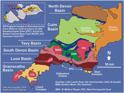
SW England is a superb natural laboratory that, in common with other basement massifs across western and central Europe, records the development and destruction of the Variscan mountain belt during and after the formation of Pangea. My research addresses regional geological evolution and the associated fundamental processes, i.e. Variscan / post-Variscan tectonics and its influence on, and interactions between, structural geology, sedimentation, magmatism, mineralisation and landscape development (further details via right-hand sidebar).
>YouTube ExeTalks video on the geology and resources of SW England (2021)
Click image for a larger version
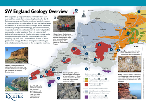
The geological evolution of SW England resulted in an outstanding endowment of natural resources that underpinned a globally significant mining industry for much of the 18th-20th centuries, and world-leading research on 'Hot Dry Rock' geothermal energy in the 1970s-1980s. Kaolinite has been produced from altered granites for almost three centuries and remains a major UK industrial mineral export. Since the mid-2000s there has been a resurgence of exploration interest in the UK's most prospective region for the metals tungsten (W), tin (Sn), copper (Cu), lithium (Li) and for deep geothermal energy. The first 'new' metal mine worked the strategically important Hemerdon W-Sn deposit in Devon between 2015-18 and was reposible for the UK becoming the fourth biggest global tungsten producer in 2017-18. In 2019, the deepest onshore borehole in the UK (UD-1, 5057 m TVD / 5275 MD) was completed as part of the United Downs Deep Geothermal Power Project and Eden Geothermal Limited completed their first deep geothermal well in late 2021 that is, just, the longest in the UK (4867 m TVD / 5277 MD). These are nationally and internationally significant projects.
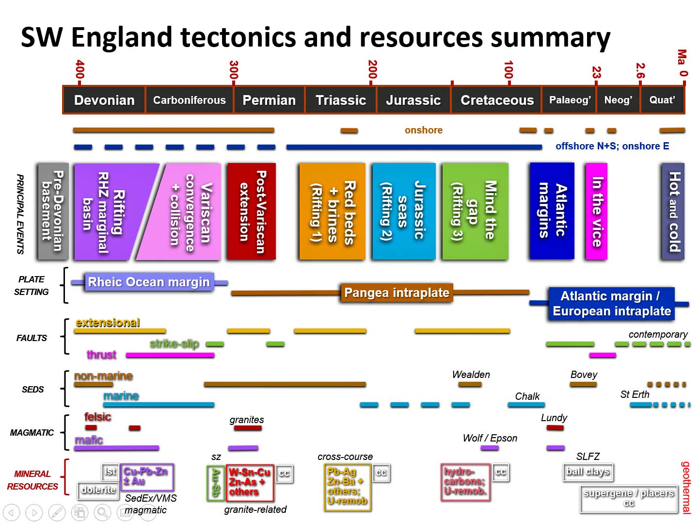
The applied research that I undertake addresses how fundamental geological processes and regional geological evolution contribute, both positively and negatively, to these resources and their exploration and production (figure below). I've been involved in collaborative research and knowledge transfer with most of the resource companies who have operated in SW England and have received NERC-funding for both geothermal- and minerals-related research.
Click image for a larger version
Current and recent funded research projects
Since 2009 I have generated PI income of £1.15M and my Co-I share of income is £0.14M.
- 2022- NERC, National Environmental Isotope Facility, grant-in-kind for collaborative study with Dr Simon Tapster - A deeper insight into batholith construction and its influence on geothermal heat production - a 4D view from the UD-1 borehole in Cornwall (supporting NERC iCASE PhD of Chris Dalby)
- 2020-2023 European Regional Development Fund. Deep Digital Cornwall (Co-I).
- 2020-2022 European Regional Development Fund (Priority Axis 4: Supporting the Shift Towards a Low Carbon Economy in All Sectors). Eden Geothermal (Co-I).
- 2019-22 NERC fourth round highlight topic: Deep subsurface heat as a potential major future energy resource - Geothermal Power Generated from UK Granites (GWatt) (NE/S003886/1, Exeter PI)
- 2018-22 NERC Industrial CASE PhD studentship with GeoScience Limited (industrial supervisor Dr Tony Batchelor) - Geological controls on upper crustal heat flow for deep geothermal energy in Cornwall (NE/R008612/1, Lead Supervisor)
- 2017-18 Satellite Applications Catapult Limited contract research - Space enabled exploration and monitoring of Cornwall lithium resources (PI).
- 2016- NERC Isotope Geosciences Facilities Steering Committee, grant-in-kind for collaborative study with Dr Simon Tapster (NIGL) - Long‐lived structural controls on magma genesis, crustal pathways and fluid traps in the post-orogenic SW England batholith: the key to forming the world‐class Hemerdon tungsten‐tin deposit?
- 2015-16 NERC Innovation Project - Tellus How - An exemplar approach for end-user innovation and follow up of major NERC environmental survey projects (NE/M021777/1, Co-I).
- 2014-18 NERC GW4+ DTP PhD - Advanced Geoscience Modelling of South West England using TELLUS high resolution multivariate data (joint with, and hosted by, the British Geological Survey).
- 2012-14 NERC/TSB Knowledge Transfer Partnership (No. 8750) with Imerys Minerals Ltd - Characterisation of the occurrence of critical metals (Nb/Ta/REE/W) + Sn within china clay operations and evaluation of processing strategies and the viability of extraction as a by-product (PI).
- 2010-12 EU FP7-ENV-2009-1 (Led by Geonardo Ltd., Hungary) - Impact Monitoring of Mineral Resources Exploitation (Co-I).
Collaboration and Knowledge Transfer
The knowledge and understanding associated with a long period of geological research in the region is underpinned by, and further contributes to, collaborative and contract minerals industry research / consultancy and knowledge transfer. Present and past collaborators include: British Geological Survey, Cornish Lithium, Cornish Tin, Cornwall Council, Cornwall Resources, CSM Associates, David Roche Geo Consulting, Eden Geothermal, EGS Energy, Elcon Western, GeoScience, Geothermal Engineering, Helford Geoscience, Imerys Minerals, JSC Altynamas, Menteri Besar Incorporated, Satellite Applications Catapult, Treliver Minerals, Tungsten West, Western United Mines and Wolf Minerals on projects that typically involve regional geology, structural geology, granites, mineralisation and/or mineralogical characterisation and their mineral / geothermal resource implications. The National Trust and The University of Plymouth have been collaborators on coastal landsliding projects.
External links for research outputs
SW England Devonian
The Devonian System was proposed by Sedgwick and Murchison in 1839 on the basis of the distinctive marine fauna in SW England; 'Devonian' is retained but all its component stages are defined in mainland Europe. Studies of SW England regional geological evolution have been hindered by considerable lithostratigraphical and structural complexity. A 30-year re-mapping programme by the British Geological Survey has demonstrated how the Upper Palaeozoic stratigraphy relates to rifting, passive margin development and subsequent Variscan convergence.
Devonian successions in the Rhenohercynian Zone of SW England
The Devonian successions of SW England record the development, and subsequent closure, of a predominantly marine basin that was either marginal to, or succeeded, the Rheic Ocean (see Variscan Tectonics). The Devonian (and Carboniferous) stratigraphy and geological evolution are very similar to the Rhenohercynian Zone of the Variscan Orogen further east (France, Belgium, Germany) and the South Portuguese Zone. Overviews of Devonian basin development and lithostratigraphy are provided by Leveridge and Shail (2011a) and the broader Upper Palaeozoic tectonic evolution by Shail and Leveridge (2009).
Gramscatho Basin / Lizard Complex (Cornwall)
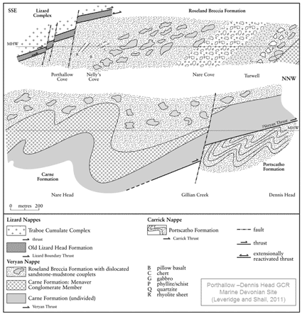
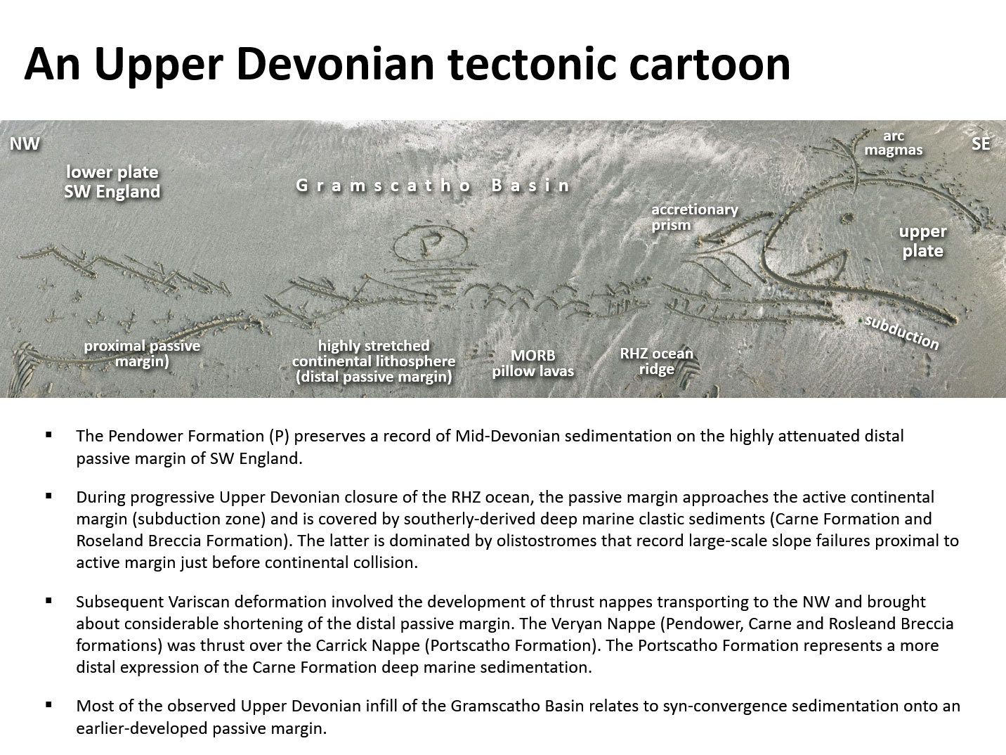
The Gramscatho Basin and Lizard Complex (see figure above) preserve partial evidence for the distal (highly attenuated + ocean floor) segment of the SW England Rhenohercynian passive margin. They also record convergent margin sedimentation, magmatism and metamorphism during the closure of this basin during (or possibly after) Rheic Ocean closure (Leveridge and Shail (2011b). Aspects of the lithostratigraphy of the Gramscatho and Looe basins on the north coast of Cornwall are described by Shail (1989) and Hollick et al. (2006). A view on the internal organisation of tectonostratigraphical units within the Lizard Complex is presented by Power et al. (1996)
Looe Basin felsic magmatism
Early Devonian syn-rift felsic magmatism is relatively rare but well known from the eastern Looe Basin in Devon. Penfound-Marks and Shail (2016) provide details of previously undescribed Early Devonian felsic igneous rocks, that they termed the Hoblyn’s Cove Felsite, that crop out in the structurally complex coastal section through the Start-Perranporth Zone between Ligger Point and Holywell Bay in Cornwall.
Lithogeochemistry of Devonian successions
A preliminary assessment of the baseline whole rock lithogeochemistry of Devonian successions in Cornwall, in areas remote from mineralisation, is provided by Scott et al. (2003).
SW England Variscan tectonics
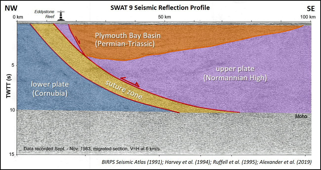
The Rhenohercynian / Rheic suture, that runs through the English Channel and Western Approaches, and lies immediately offshore of Cornwall, records the last occasion that British continental lithosphere formed part of a convergent plate margin. The suture forms the boundary between the Rhenohercynian and Saxothuringian zones of the Variscan orogen.
Plate tectonic models
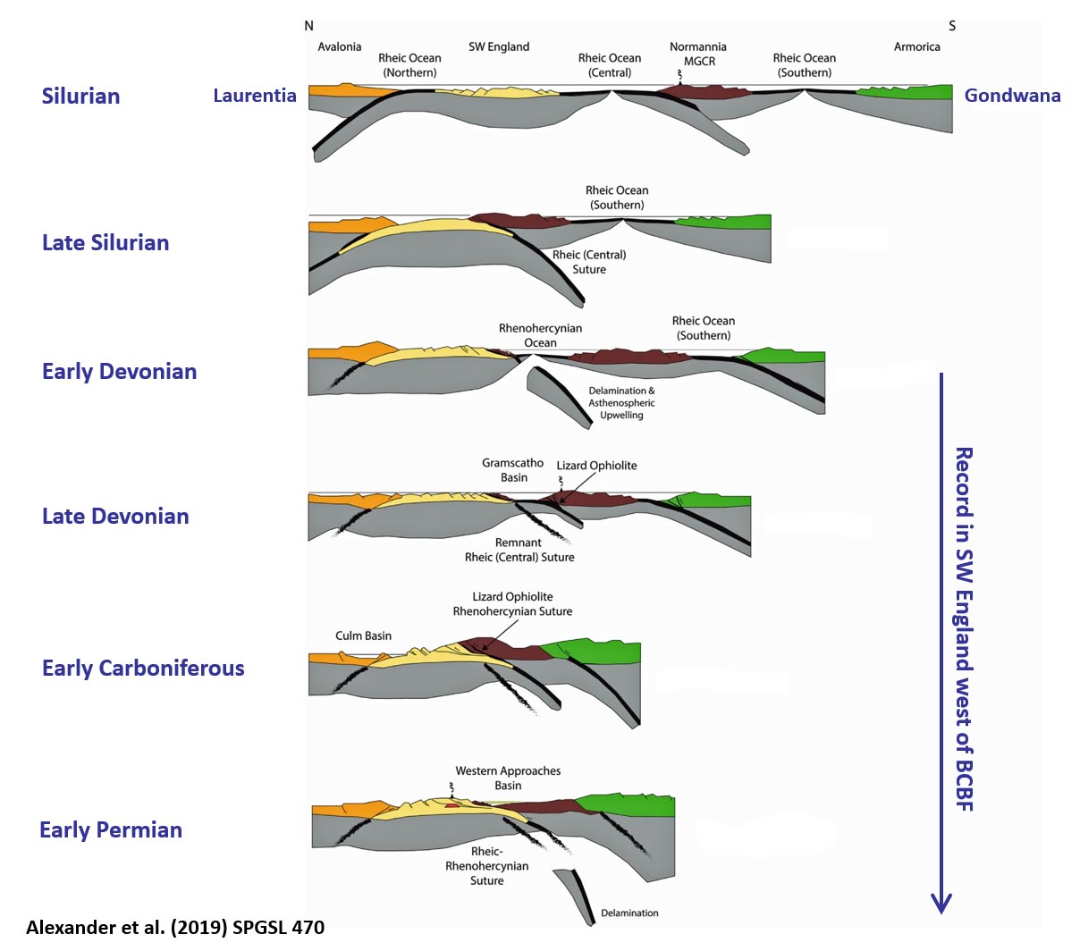
There is no single widely accepted plate tectonic model for the Variscan evolution of this part of western Europe. Some of the admissible possibilities and some of the problems, based on data from SW England and adjacent areas, are outlined in Shail and Leveridge (2009). The Devonian and Carboniferous geology of SW England records the development and subsequent closure of either a: (1) marginal basin immediately north of the Rheic Ocean or (2) successor basin to the Rheic Ocean. Earlier work on the application of sediment provenance models to the tectonic environment of Rhenohercynian sedimentary rocks in Cornwall and Germany is presented in Floyd et al. (1991) and Floyd et al (1990). One of the challenges in tectonic reconstructions is that the nature of pre-Devonian basement in SW England is very poorly constrained. Indirect evidence suggests that it shares some characteristics with the Meguma Terrane in Maritime Canada (Nance et al., 2015). A recent appraisal of the tectonic significance of the suture south of SW England has been provided by Alexander et al. (2019) - see below.
Variscan convergence in SW England
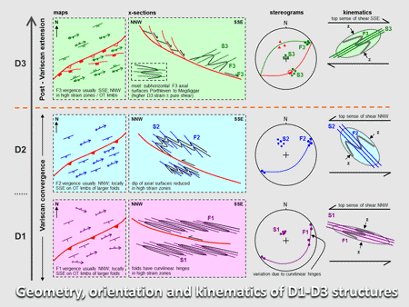
The proximal parts of the northern passive margin (Looe Basin northwards - see Devonian Stratigraphy) are represented by the infill of half / full graben formed by moderate thinning of continental lithosphere; these basins were subsequently strongly inverted during Variscan continental collision. The distal parts of the passive margin (partially accreted together with proximal syn-convergence sediments) are represented by the Gramscatho Basin / Start Complex / Lizard Complex - see below. The distal and proximal segments were juxtaposed along the Start-Perranporth Zone - a major D2 thrust zone; a substantive part of the intervening passive margin may have been occluded. Syn-convergence sedimentation in the later Carboniferous occurs within the Culm Basin and is primarily related to uplift along the frontal segment of the Bristol Channel - Bray Fault as SW England approached and docked with the remainder of southern Britain. Variscan thrust-related covergence had ceased in SW England by c. 305 Ma (late Carboniferous) and briefly replaced by a strike-slip regime before the onset of post-Variscan extension. Descriptions of outcrop-scale structures related to Variscan convergence are provided by Alexander and Shail (1995), Alexander and Shail (1996), Shail and Leveridge, 2009, Hughes et al. (2009) and Alexander et al. (2019). A preliminary evaluation of lineaments across SW England, using Object-Based Image Analysis, which in part reflects the convergence history, has been presented by Yeomans et al. (2018).
SW England post-Variscan tectonics
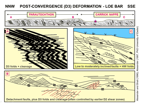
Variscan convergence ended in the late Carboniferous (c. 305 Ma). It was succeeded across NW Europe by a dextral transtensional regime that persisted through most of the Early Permian. Its effects in SW England were primarily manifested in the extensional reactivation of the Rheic-Rhenohercynian suture, Bristol Channel-Bray Fault and other Variscan thrust faults, and by the strike-slip reactivation of NW-SE Variscan transfer faults. The evidence for reactivation of the offshore Rheic-Rhenohercynian suture zone is summarised by Alexander et al. (2019).
Onshore evidence for latest Carboniferous - Early Permian post-Variscan extension
During this latest Carboniferous - Early Permian extensional episode, a wide variety of regional D3 structures (folds, foliations, faults, shear zones), typically associated with a top-sense-of-shear to the SSE, were developed in Devonian / Carboniferous rocks and the earliest (>289 Ma) Cornubian granites. Descriptions of these structures, their kinematics, position in the regional deformation chronology and timing relative to granite generation and emplacement, are presented in Alexander and Shail (1995), Alexander and Shail (1996) and Hughes et al. (2009). A preliminary evaluation of lineaments across SW England, using Object-Based Image Analysis, which in part reflects the post-convergence history, has been presented by Yeomans et al. (2018).
Consequences of extension for magmatism and sedimentary basin development
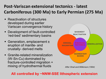
The extension brought about lithospheric thinning that resulted in the generation and emplacement of lamprophyres, basalts and granites, and the development of 'red-bed' sedimentary basins (Shail and Wilkinson, 1994; Shail et al. 2003; Shail and Leveridge, 2009; Dupuis et al. 2015; Dupuis et al. 2016; Simons et al. 2016). The relationship between extensional reactivation of the Rhenohercynian-Rheic suture and Early Permian development of Plymouth Bay Basin is addressed by Harvey et al. (1994) and Alexander et al. (2019). The kinematics and palaeostress analyses of both D3 and post-D3 structures, developed during the latest Carboniferous to late-Triassic are summarised in Shail and Alexander (1997).
SW England granites
Cornubian Batholith and associated igneous rocks (Early Permian)
The Early Permian igneous rocks of SW England and the adjacent continental shelf form one of the major igneous provinces in the UK. The best known expression of felsic magmatism is the Cornubian Batholith, comprising composite granite plutons, stretching eastwards from beyond the Isles of Scilly, through Cornwall, to Dartmoor in Devon. It is associated with subtantial rhyolite / microgranite intrusive sheets ('elvans') and the remnants of formerly more extensive rhyolite lavas and pyroclastic rocks. The smaller and separate Haig Fras Batholith crops out on the sea floor almost 100 km NW of the Isles of Scilly.
Two-mica (G1) and muscovite (G2) granites
The batholith was constructed over almost 20 Ma during the Early Permian. The most recent classification of near-surface granites by Simons et al. (2016) defines five principal types (G1-G5). The earliest expression of magmatism are the two-mica (G1) and muscovite (G2) granites, represented by the upper parts of the Isles of Scilly, Carnmenellis and Bodmin Moor plutons, and associated dykes and lavas (292-290 Ma). There was a brief hiatus in magmatism from 289-286 Ma and the initial expression of the second stage of emplacement are two-mica (G2) stocks, e.g. Cligga Head (<286 Ma).
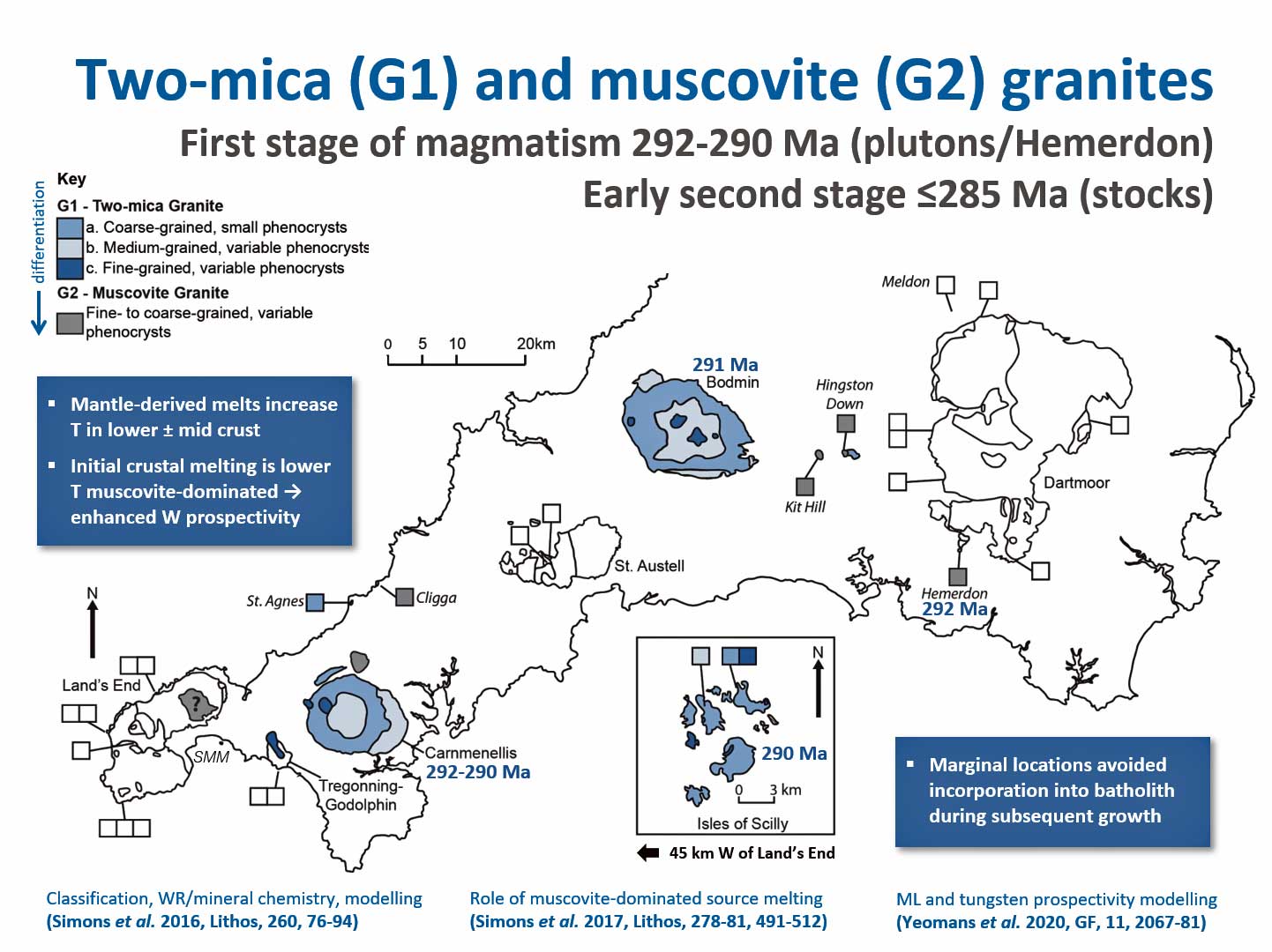
Click image for larger version
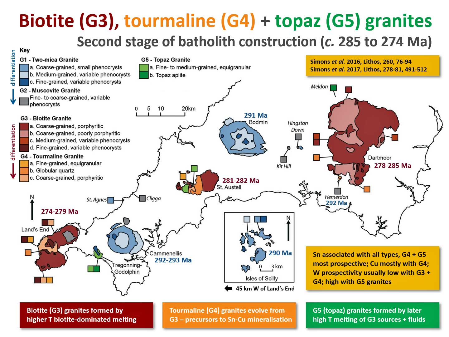
Biotite (G3), tourmaline (G4) and topaz (G5) granites
The latter magmatic epsiode is primarily represented by the biotite (G3) and tourmaline (G4) granites that form the dominant near-surface expression of the Land's End, St Austell and Dartmoor plutons. The tourmaline (G4) granites formed by differentiation of the biotite granite magmas and are likely precursors to magmatic-hydrothermal mineralisation. Topaz (G5) granites have a limited near-surface expression, primarily in the Tregonning and St Austell plutons and the Meldon Aplite and have the highest lithium contents within the batholith.
Click image for larger version
Contemporaneous mafic igneous rocks
Less well known are the mafic igneous rocks that occur: (1) around Exeter, at or near the base of Permian post-Variscan sedimentary successions (lamprophyre and basalt lavas / sills), (2) in the pre-Permian Variscan basement further west (lamprophyre dykes), and (3) within the Permian post-Variscan sedimentary basins of the western English Channel and SW Approaches.
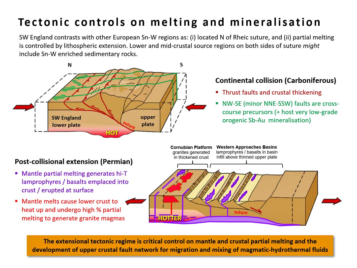
Tectonic controls on magmatism and mineralisation
Magmas were generated episodically over a 20 Ma period from c. 292 to 274 Ma, primarily by extensional thinning of continental lithosphere previously thickened during Variscan convergence. Mafic igneous rocks resulted from mantle partial melting and felsic igneous rocks largely by partial melting of the lower crust, albeit strongly influenced by underplating / emplacement of mantle-derived melts. Felsic magmatism was restricted to relatively narrow zones in the immediate lower plate / footwall of the Rhenohercynian / Rheic suture (generating the Cornubian Batholith) and the frontal segment of the Bristol Channel Fault Zone (generating the Haig Fras Batholith). The thermal evolution of the lithosphere and onset of partial melting was controlled by superposition of post-Variscan extension and Variscan convergence.
Click image for larger version
Work undertaken with others includes recognition of the role of extensional tectonics and mantle melting in lamprophyre and granite generation within the province (Shail and Wilkinson, 1994; Shail et al., 2003; Dupuis et al., 2015; Dupuis et al., 2016; Simons et al., 2016), characterisation of composite granite plutons (Powell et al., 1999; Salmon and Shail, 1999; Simons et al., 2016) and aplite-pegmatite sheets (Breiter et al., 2018), magmatic state fabric development (Kratinová et al., 2003; Kratinová et al., 2010), contact aureole tectonics and emplacement (Hughes et al., 2009; Pownall et al., 2012), characterisation of zircon chemistry (Breiter et al., 2016) and LA-ICPMS zircon dating (Neace et al., 2016).
The Lundy Granite (Palaeogene) . . . and now for something completely different . . . or is it?
The Lundy Granite, located in the Bristol Channel off the north Devon coast, forms part of the Lundy Igneous Complex, and is the southernmost substantive expression of magmatism within the British-Irish Palaeogene Igneous Province and the wider North Atlantic Igneous Province. Charles et al. (2017) provided the first U-Pb zircon ages for the granite and confirmed a Palaeocene age (59.8 ± 0.4 – 58.4 ± 0.4 Ma). Its Qz + Pl + Kfs + Bt ± Grt ± Tpz mineralogy and peraluminous character contrasts with similar age granites farther north but are similar to the granites of the Early Permian Cornubian Batholith.
The anomalous southerly location of the Lundy Igneous Complex is probably a consequence of mantle melting arising from the superimposition of localised lithospheric extension, related to intraplate strike-slip tectonics, with the distal ancestral Icelandic plume. Granite generation primarily reflects crustal partial melting during the emplacement of mantle-derived melts. The peraluminous character indicates a fundamental crustal source control between contrasting peri-Gondwanan (Lundy) and Laurentian basement provinces farther north.
SW England mineralisation
Distinct episodes and styles of mineralisation reflect the regional tectonic evolution of SW England (view 'metals + rocks' row in table).
Syn-rift mineralisation (Early Devonian - Early Carboniferous)
Devonian and Early Carboniferous syn-rift successions locally host low grade / tonnage SedEx and VMS mineralisation styles that subsequently underwent Variscan deformation and low-grade regional metamorphism; some was locally remobilised within . . .
Late-orogenic mineralisation (Latest Carboniferous - ?earliest Permian)
Late-orogenic shear zone quartz-Sb-Au + base metal veins associated with late Variscan (latest Carboniferous-?earliest Permian) NW-SE strike-slip transfer faults, active during thrusting and early extensional recativation, are best known from North Cornwall but occur more widely (e.g. Camm et al., 1996), such as within the 'killas' in the Dolcoath section of South Crofty Mine, and typically have grades of up to 1-2 ppm Au over 0.2-0.3 m intersections.
Granite-related mineralisation (Early - Mid Permian)
Of overwhelming historical, and continuing present / future, economic significance are the Early-Mid Permian magmatic-hydrothermal W-Sn-Cu-Zn-Pb vein deposits associated with the Cornubian Batholith. The role of partial melting and fractional crystallisation in controlling variable melt enrichment in Li, Be, Ga, Nb, Ta, In, Sn, Sb, W and Bi across the different Cornubian granite suites (G1-G5) was modelled by Simons et al. (2017); Sn and B distributions were modelled by Williamson et al. (2010).
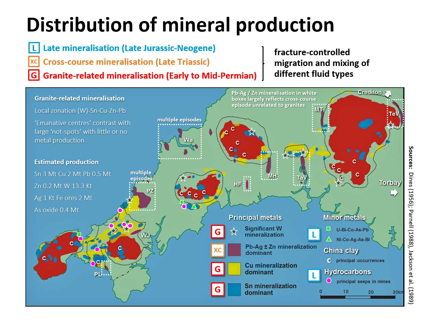 Click image for larger version
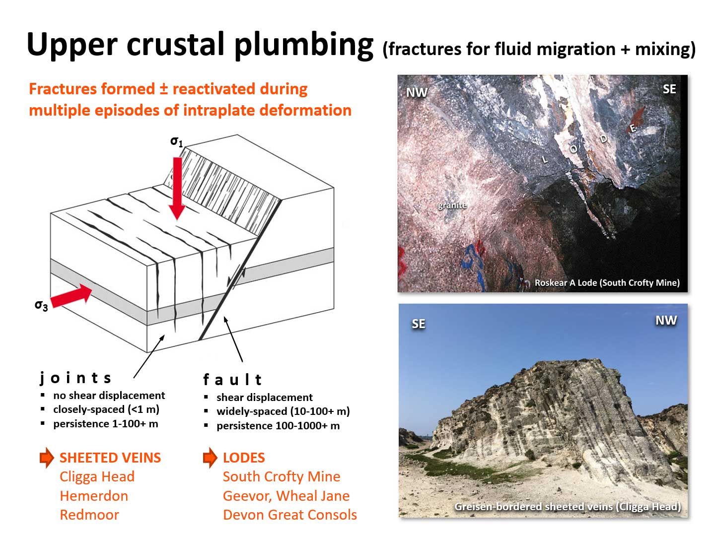
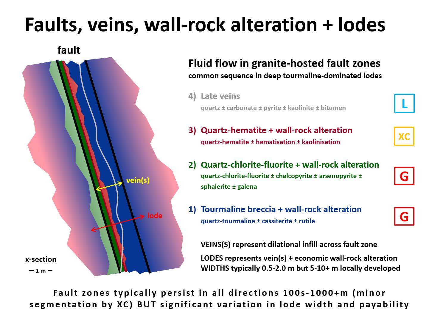
Emplacement of these variable composition magma batches during pluton construction was associated with the release of enormous volumes of magmatic-hydrothermal fluids. These migrated through actively propagating, tectonically-controlled, extensional / strike-slip fault and joint systems and mixed to varying degrees with meteoric and other fluids (contact metamorphic / red-bed brines).
Click image for larger version
The resulting mineralisation occurs both in the granites and their host rocks and may include multiple parageneses in zones of repeated fluid mixing. Quartz tourmaline cassiterite parageneses from the largely unmineralised southern lobe of the Land's End Granite are described by LeBoutillier et al. (2002). Polymetallic quartz-chlorite-sulphide-fluorite metasedimentary rock hosted assemblages from near surface in South Crofty Mine have been described by LeBoutillier et al. (2000) and across the province by LeBoutillier et al. (2003).
Click image for larger version
The occurrence of a mantle helium signature in most magmatic-hydrothermal parageneses was outlined by Shail et al. (2003). A comprehensive description of indium mineralisation across SW England was provided by Andersen et al. (2016). Preliminary reports of the geological factors that influenced the formation of the world-class Hemerdon W-Sn deposit, being worked by Wolf Minerals, have been provided by Shail et al. (2017) and Tapster et al. (2017).
Cross-course mineralisation (Mid-Triassic)
Mid-Triassic 'cross-course' mineralisation, related to the migration of 'red-bed' basinal brines through granites and their host rocks, also occurs within the mafic/ultramafic rocks of the Lizard Complex (Power et al., 1997). A record of mining wastes within the contemporary sediments of the River Teign, largely related to cross-course mineralisation, is described by Simons et al. (2011).
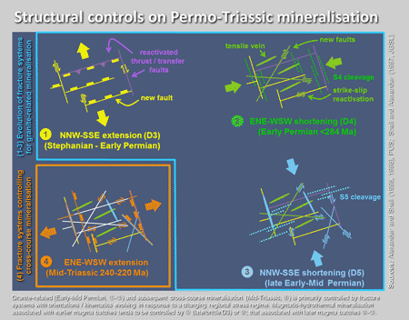
Structural controls on mineralisation
The variable orientation of veins hosting granite-related magmatic hydrothermal mineralisation and basinal-brine cross-course mineralisation is partially explained by changing regional and local palaeostress regimes during the latest Carboniferous-late Triassic (Shail and Wilkinson, 1994; Alexander and Shail, 1995; Alexander and Shail, 1996; Shail and Alexander, 1997); see figure below. A preliminary evaluation of lineaments across SW England, using Object-Based Image Analysis, has been presented by Yeomans et al. (2018).
Estuary sediments
A record of granite-related and cross-course mineralisation, as well as china clay extraction, is preserved in estuary sediments around SW England; there are also some really interesting diagenetic minerals. A concise readable overview is provided by Pirrie and Shail (2018).
SW England geothermal
Overview
Cornwall and Devon have locally high surface heat flows associated with elevated levels of U, Th and K within the granites of the Cornubian Batholith. It is the most prospective area in the UK for the development of deep geothermal energy (Beamish and Busby 2016). Previous investigations include the £42M CSM Hot Dry Rock research programme (1973-1991), based at Rosemanowes Quarry in the Carnmenellis Granite, where several deep research boreholes were drilled to a maximum depth of 2600 m.
There has been a renewed impetus over the last decade to ensure that the regional potential for deep geothermal power is further investigated and developed; this forms one of the strategic priorities for Cornwall Council.
>Could Cornish granite unlock deep geothermal energy in England?
Online article and interview in Power Technology (May 2019)
United Downs Deep Geothermal Power Project (St Day - Carn Marth Granite)
 The United Downs Deep Geothermal Power (UDDGP) Project, run by Geothermal Engineering Limited, targetted a granite-hosted segment of the Porthtowan Fault Zone and is developing a 1-3 MW pilot power plant.
Drilling of the 5058 m (TVD) UD-1 production well, which is the UK's deepest onshore borehole, commenced on 7th November 2018 and was completed on 23rd April 2019. The 2214 m (TVD) UD-2 injection well was completed on 28th June 2019. An extended testing programme is currently taking place, before construction of the power plant.
The rationale and science behind the project are explained in this brilliant video. A summary of site selection and an initial assessment of the structurally-controlled reservoir from downhole data has been provided by Reinecker et al. (2021).
Eden Geothermal Project (Bodelva - St Austell Granite)
 Eden Geothermal Ltd has been set up by three partners: Eden Project, EGS Energy Ltd, and Bestec (UK) Ltd. The initial drill site is located to the north of the Eden Project biomes, in the southern part of the St Austell Granite, and has targetted the NNW-SSE "Great Cross-course" fault system.
Drilling of the first well, EG-1 (MD 5277 m BGL; TVD 4867 m BGL), commenced on 17th May 2021 and maximum depth was reached on 26th October 2021. It is presently (just!) the longest geothermal well in the UK.
The Project will include a one-year period of heat production from the single deep well, using a ‘co-axial’ circulation system, that will be used to provide direct heat to existing facilities at Eden and to new greenhouses. This will be the first phase of an anticipated two well development. It will pave the way for the second phase and another deep well and an electricity plant.
The project is summarised here.
My research related to deep geothermal energy
The geological uncertainties related to the development of deep geothermal largely relate to understanding regional to local variations in crustal heat flow and fracture permeability. These are closely aligned with my research interests in SW England granites, SW England mineralisation and post-Variscan tectonics. The geology-related deep geothermal research projects that I’m involved in are summarised below:
Eden Geothermal

Exeter PI: Professor Hylke Glass; Exeter Co-I: Dr Robin Shail;
PhD title: Geological controls on heat production and the evolution of fracture systems.
PhD student: Philip Henes
Supervisory team: Dr Robin Shail (lead), Professor Hylke Glass
The research will use data derived from well-cuttings and downhole geophysical logging to evaluate the geological controls on heat production and fluid flow in the vicinity of the test site. These data will help address how the distribution of heat-generating elements, U, Th, K, varies with depth and so contributes to the heat resource and geothermal gradient. Downhole geophysical logs will be used to determine the orientation, aperture, spacing, distribution and other characteristics of the fracture and vein populations. These are the primary controls on permeability and fluid flow. The vein systems reflect multiple episodes of fracture formation / reactivation and fluid flow - they are, in essence, markers of palaeo-geothermal systems. The nature of vein infills is strongly correlated with wall-rock alteration / strength of the host granite; this, together with re-fracturing and/or dissolution of vein infill exerts an important control on permeability and, potentially, the chemistry of contemporary fluids. The objective is to understand the extent to which multiple generations of fluid flow have contributed to: (1) enhancement, and (2) reduction of permeability.
A second PhD project "Estimation of the geothermal resource" is being undertaken by Ben Adams and is supervised by Professor Hylke Glass (lead) and Dr Robin Shail.
Funding: European Regional Development Fund + College of Engineering Mathematics and Physical Sciences

Geothermal Power Generated from UK Granites (GWatt)
 NERC fourth round highlight topic (2019-2022): Deep subsurface heat as a potential major future energy resource (NE/S003886/1)
Exeter PI: Dr Robin Shail; Exeter Co-I: Dr Matthew Eyre
Research Fellow: Chris Yeomans
Exploitation of UK deep geothermal resources has been held back by knowledge gaps relating to permeability and fluid/heat flow at reservoir target depths of 3-5 km; the risks associated with these uncertainties have inhibited private investment. Geothermal Power Generated from UK Granites (GWatt) seeks to reduce these risks, and so contribute to the uptake of deep geothermal energy, by:
- Increasing knowledge of the geological conditions needed for deep fracture-controlled fluid flow within granitic rocks.
- Developing a quantitative understanding of the heat resource and sustainability of the geothermal reservoir.
- Constructing robust geological risk assessments based on well-established oil and gas uncertainty quantification and optimisation methods, with a view to reducing perceived risks.
- Applying the integrated results of site-specific research to new geothermal exploration models for other granites, particularly those in SW England.
The project consortium includes research, business and local government partners. Research collaboration between GWatt and the United Downs Deep Geothermal Power (UDDGP) Project will provide access to a unique resource of downhole fluids, rock samples, geophysical logs, flow data and seismic data. In addition to CSM, the project comprises the British Geological Survey (project co-ordinator) and Heriot-Watt University who provide complementary skills in deep geothermal resource assessments, deep fracture fluid flow, rock/fluid interactions, reservoir modelling and the quantification of geological uncertainties.
Funding: UKRI-NERC
Geological controls on upper crustal heat flow in Cornwall
 NERC Industrial CASE PhD studentship with GeoScience Limited (2018-2022) "Geological controls on upper crustal heat flow for deep geothermal energy in Cornwall" (NE/R008612/1)
PhD student: Chris Dalby
Supervisory team: Dr Robin Shail, Dr Tony Batchelor (GeoScience Limited), Professor Frances Wall, Dr James Hickey
The purpose of the project is to address uncertainties regarding heat production and conduction models in the Cornish crust which include: (i) radioactive elements U, Th and K are not present in sufficiently high quantities within the previously investigated upper parts of the granite to account for observed heat flow, (ii) He-4 production from historical deep geothermal wells is higher than anticipated, (iii) geophysical modelling has progressively reduced the interpreted volume of the Cornubian granites. These inconsistences imply substantive heat source(s) may occur within, or below, the deeper parts of the batholith.
Drilling cuttings from the UDDGP Project will be used to evaluate mineralogical and geochemical changes in depth within the granite to evaluate heat production. These data will be complemented by those obtained during downhole logging. Comparisons between modelled heat production and measured heat flow data will be evaluated in terms of the potential role of upper crustal convective fluid flow and/or mid / lower crustal and mantle heat contributions (using existing deep geophysical data and an understanding of admissible scenarios during the post-Variscan tectonic evolution of SW England).
Funding: UKRI-NERC + GeoScience Limited
Teaching
I am Module Co-ordinator (MC) for Dynamic Planet (Year 1) and Structural Geology and Tectonics (Year 2). I contribute to several other undergraduate modules, primarily field-based skills teaching, and supervise Summer Vacation Projects. I also teach on the MSc Mining / Exploration Geology programme and supervise Research Project and Dissertation students - typically those with a SW England resources and/or structural geology focus.
-
Year 2
+ Structural Geology and Tectonics (CSM2182) MC
+ Geological Mapping Techniques (CSM2184)
-
Year 3
+ Exploration Techniques (Underground Geological Mapping) (CSM3151)
+ Summer Vacation Project (CSM3379)
-
MSc
+ Ore Deposit Geology (CSMM195)
+ Research Project and Dissertation (CSMM047)
