
Urban Water
Urban water
Urban water
Urban water
Our research investigates how the management of drainage systems can address issues of flooding and excessive spill frequency. Please see below for some of our research projects related to urban water.
Current Projects
Recent Projects
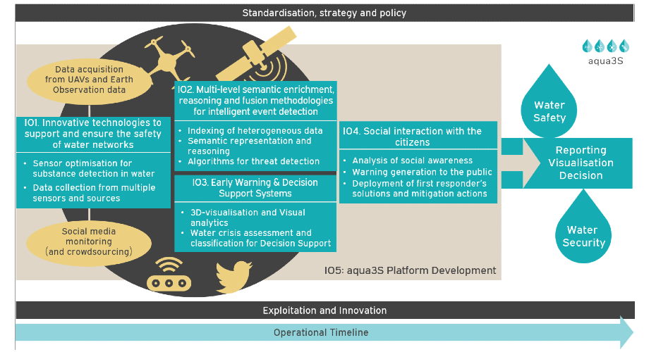
The aqua3S project aims to create strategies and methods that will enable water facilities to easily integrate solutions regarding water safety, through a combination of novel technologies in water safety and the standardisation of existing sensor technologies.
Exposure of citizens to potential disasters has led to vulnerable societies that require risk reduction measures. Drinking water is one of the main risk sources when its safety and security are not ensured.
aqua3S combines novel technologies in water safety and security, aiming to standardize existing sensor technologies complemented by state-of-the-art detection mechanisms. aqua3S can propose innovative solutions to water facilities and responsible authorities in order to detect and tackle water-related crises in a timely manner.
On the one hand, sensor networks are deployed in water supply networks and sources, supported by complex sensors for enhanced detection; on the other hand, sensor measurements are supported by videos from Unmanned Aerial Vehicles (UAVs), satellite images and social media observations from citizens that report low-quality water in their area (e.g. by colorization); introducing this way a bottom-up approach which raises social awareness and, also, promotes interactive knowledge sharing.
The proposed technical solution is designed to offer a very effective detection system, taking into account the cost of the aqua3S platform and target at a very high return-on-investment ratio.
The main strategy for the integration of aqua3S’ solution into the market is designed on the standardization of the proposed technologies and the project’s secure platform.
Visit the aqua3s website for further information.
So far, individual water companies have been able to use open data and Artificial Intelligence to gradually improve their performance in delivering services. Through this initiative, Severn Trent are leading this cross-sector coalition to go much further, piloting an autonomous system to monitor an entire waste catchment. By bringing together extensive testing with emerging technologies, this approach can work through huge amounts of data to provide real-time insights to help water companies reduce the risk of flooding and sewerage pollution in a catchment: delivering benefits for both customers and the environment.
Through this project, the delivery team will be developing a tried and tested blueprint for how this approach can be scaled across the UK. More broadly, the team hope that this project can be a catalyst for wider use of AI in the water sector, building trust and demonstrating the value of this important technology.
Led by: Severn Trent Water
Partners: South West Water, Southern Water, Thames Water, Hafren Dyfrdwy Water, Northumbrian Water, Microsoft, Rockwell, British Telecom, Blackburn-Starling, 8power, National Cyber Security Centre, University of Exeter.
Funder: Ofwat Water Breakthrough Challenge
For further information, please visit the Ofwat website.
The aim of this Knowledge Transfer Partnership (KTP) is to develop and embed a toolset utilising Bayesian Optimisation and CFD techniques in order to enable optimisation of product function and manufacturability, and accelerate the product development process.
This is the latest part of a long term collaboration between the University of Exeter (Prof Gavin Tabor, Prof Jonathan Fieldsend) and Hydro International Ltd, developing Computational Fluid Dynamics (CFD) and Machine Learning techniques for SUDs product design. Hydro International provides products and services in the water treatment and drainage sectors including wastewater, stormwater and industrial water treatment products, and flow controls for urban drainage systems. The objective of the project is to use Bayesian Optimisation to optimise the separation of particulate waste from water using a cyclone separator very similar in function to a Dyson vacuum cleaner, but for water rather than air. The aim is for the computer to "learn" better designs for the separator trays which are at the heart of the system, providing key new IP for the company as well as a design tool which can be applied to other products in their range.
This project aims to develop and demonstrate an effective emergency flood planning and management approach based on the synergetic use of on-site, measured information collected by UAS’s with mathematical models for flood modelling, evacuation route planning and dynamic emergency resource allocation.
This project focuses on using UASs to collect and collate pertinent information about an unfolding flooding disaster. This will be combined with accelerated flood inundation models to generate detailed evacuation plans, and to predict the nature and progress of the flooding to improve allocation of emergency resources, build community flood resilience, save lives and reduce economic damage.
For more information visit their website.
ESPRIT aimed to establish strong collaborations between the UK and Chinese partners to advance our scientific understanding of urban flooding and thus enhance flood resilience.
Through engagement with five Chinese cities that have suffered severe flooding in the past few years, the consortium created a framework of systems modelling to develop innovative solutions for strengthening cities’ resilience against flooding. The framework evaluated the effectiveness of interventions to support decision makers in strategic planning and adaptation measures.
ESPIRT worked closely with Chinese local governments and Torbay Council, UK as the project’s case studies, so as to address the common existing challenges in urban flood risk management. Various adaptation strategies were tested to compare their suitability in different weather and urban conditions. Local governments from both countries also shared their experiences and evaluated the solutions. As a result, a guidance for embedding flood resilience analysis in urban planning was established so as to safeguard future cities from the impact of flooding.
The main objectives of EU-CIRCLE were to define a holistic climate resilience infrastructure model and its constitutional components to develop the technical solution that will implement it and to extensively validate it in real world test cases.
Background
It is presently acknowledged and scientifically proven than climate related hazards have the potential to substantially affect the lifespan and effectiveness or even destroy of European Critical Infrastructures (CI), particularly the energy, transportation sectors, buildings, marine and water management infrastructure with devastating impacts in EU appraising the social and economic losses. The main strategic objective of EU-CIRCLE is to move towards infrastructure network(s) that is resilient to today’s natural hazards and prepared for the future changing climate. Furthermore, modern infrastructures are inherently interconnected and interdependent systems ; thus extreme events are liable to lead to ‘cascade failures’.
EU-CIRCLE’s scope is to derive an innovative framework for supporting the interconnected European Infrastructure’s resilience to climate pressures, supported by an end-to-end modelling environment where new analyses can be added anywhere along the analysis workflow and multiple scientific disciplines can work together to understand interdependencies, validate results, and present findings in a unified manner providing an efficient “Best of Breeds” solution of integrating into a holisti resilience model existing modelling tools and data in a standardised fashion.
It, will be open & accessible to all interested parties in the infrastructure resilience business and having a confirmed interest in creating customized and innovative solutions. It will be complemented with a webbased portal.The design principles, offering transparency and greater flexibility, will allow potential users to introduce fully tailored solutions and infrastructure data, by defining and implementing customised impact assessment models, and use climate / weather data on demand.
Objectives:
- From response & prevention to resilience
- Balancing Priorities
- CIRP, Advanced Modelling and Simulation Environment for Assessing Climate Impacts to Infrastructures
- SimICI a unique reference test-bed
- Innovative local impact assessments
- Reduce uncertainties
- Contribute to Climate impact assessment standards
- Scientific Support to policies and CI stakeholders
- EU-CIRCLE as a vehicle to Industry Growth
Link to EU Policies
EU-CIRCLE lies on the intersection of several European policies and initiatives spanning across different domains. These include:
The EU Internal Security Strategy, and more importantly the 5th Objective to Increase Europe’s resilience to crises and disasters. This calls for an all-hazards approach to threat and risk assessment: guidelines for disaster management will be drawn up, national approaches will be developed, cross-sectoral overviews of possible risks will be established together with overviews of current threats, an initiative on health security will be developed, and a risk management policy will be established.
The EU Climate Adaptation Strategy (SWD (2013) 299), acknowledges that climate related hazards will have a defining impact on the status and operational capacity of European critical infrastructures, and society as a whole. More specifically, the following points have been identified:
- Asset deterioration and reduced life expectancy
- Increases in Operational Expenditure (OPEX) and the need for additional Capital Expenditure (CAPEX)
- Loss of income
- Increased risks of environmental damage and litigation
- Reputation damage
- Changes in market demand for goods and services
- Increased insurance costs or lack of insurance availability.
The European Programme for Critical Infrastructure Protection (Directive 2008/114/EC), on the identification and designation of European Critical Infrastructures and the assessment of the need to improve their protection. Identified Critical infrastructures which, if disrupted or destroyed, would have a serious impact on health, safety, security or economic well-being of citizens and/or effective functioning of government in Member States. The Directive requested an all-hazards risk framework treating natural hazards and terrorism alike, setting the principles upon which the Member States must ensure that an operator security plan (OSP) or an equivalent measure for each designated CI is devised.
The Flooding from Intense Rainfall programme was a NERC-led five-year programme which contributed to our understanding of the risks associated with flooding from high-intensity convective storms.
The FFIR was led by the University of Reading and included three work packages, each with a specific goal:
WP1 Project FRANC:
Forecasting Rainfall exploiting new data Assimilation techniques and Novel observations of Convection
Goal: To improve short-range forecasts of severe weather via the reduction of initial condition errors
WP2 Project SINATRA:
Susceptibility of catchments to INTense RAinfall and flooding
Goal: To advance scientific understanding of the processes determining the probability, incidence, and impacts of FFIR
WP3 Project TENDERLY:
Towards END-to End flood forecasting and a tool for ReaL-time catchment susceptibility'
Goal: To demonstrate end-to-end forecasting of flooding from intense rainfall, improve the effectiveness of flood risk management and underpin flood forecasting and risk management through the gathering of high quality scientific and community sourced data.
The CWS team worked on both the SINATRA and TENDERLY projects to develop an advanced inundation model that adopts high resolution rainfall measurement and forecast information for near real-time modelling and forecasting, to improve scientific understanding and risk management of FFIR.
FIWARE is a smart solution platform, funded by the European Commission (2011-16) as a major flagship PPP, to support SMEs and developers in creating the next generation of internet services, as the main ecosystem for Smart City initiatives for cross-domain data exchange/cooperation and for the NGI initiative. So far little progress has been made on developing specific water-related applications using FIWARE, due to fragmentation of the water sector, restrained by licensed platforms and lagging behind other sectors (e.g. telecommunications) regarding interoperability, standardisation, cross-domain cooperation and data exchange.
Fiware4Water intends to link the water sector to FIWARE by demonstrating its capabilities and the potential of its interoperable and standardised interfaces for both water sector end-users (cities, water utilities, water authorities, citizens and consumers), and solution providers (private utilities, SMEs, developers). Specifically we will demonstrate it is non-intrusive and integrates well with legacy systems. In addition to building modular applications using FIWARE and open API architecture for the real time management of water systems, Fiware4Water also builds upon distributed intelligence and low level analytics (smart meters, advanced water quality sensors) to increase the economic (improved performance) and societal (interaction with the users, con-consensus) efficiency of water systems and social acceptability of digital water, by adopting a 2-Tier approach:
- Building and demonstrating four Demo Cases as complementary and exemplary paradigms across the water value chain (Tier#1);
- Promoting an EU and global network of followers, for digital water and FIWARE (cities, municipalities, water authorities, citizens, SMEs, developers) with three complementary Demo Networks (Tier#2).
The scope is to create the Fiware4Water ecosystem, demonstrating its technical, social and business innovative potential at a global level, boosting innovation for water.
Why Fiware4Water?
The prerequisite of Fiware4Water is to lever the barriers of the water digital sector that is facing a low level of maturity in the integration and standardization of ICT solutions, in the business processes of these solutions and relative implementation of legislative framework, as described by the ICT4Water cluster.
The related needs are how to exploit the value of data for the water sector, how to develop and test robust and cyber-secured systems, how to create water-smart solutions and applications how to ensure interoperability and higher information capacity and how to design tailored solutions addressing a real need such as optimisation, prediction, diagnosis, real-time monitoring.
For further information, please visit the Fiware4Water website.
CWS is leading an international research consortium, including colleagues from University of Exeter, UK, University of Central Florida (UCF), US, and Tsinghua University (THU), China, to develop the advanced methodology in the project Flood impact assessment in mega cities under urban sprawl and climate change funded by the Global Innovation Initiative (GII), which aims to support multilateral research collaboration to address global challenges.
Prof Dragan Savic at CWS is the coordinator of the consortium, supported by Prof Ni-Bin Chang at UCF and Prof Binliang Lin at THU. The project aims to investigate the future flood impact as the consequence of the combination of urban development and climate change in three mega cities - London, New York and Beijing. Two of them are coastal cities facing threats from both heavier precipitation and sea level rise.
An urban growth model will be developed using the satellite sensor data and the artificial intelligence techniques to detect the changing trends of urban sprawl and to project future urban growth scenarios in these three cities. The parameters derived from the urban growth model will be used in hydraulic modelling to assess the flood impact for the whole city in the 2050s.
The state-of-the-art hydraulic models will be set up to simulate flooding in complex urban environment with high spatial resolution. The multi-disciplinary collaboration will bring the experts from the UK, the US and China together to create an operational framework for analysing flood impact associated with various urban development conditions and climate change scenarios at the mega-city scale. The results can inform urban planners about the potential increase of flood risk such that better urban development strategies can be developed and implemented to mitigate flood impact.
This fellowship investigates how to develop smart water infrastructure systems using Information and Communication Technologies (ICT) and big data already available in the water industry in response to a changing environment including extreme weather.
There is a critical need to develop new advanced data and visual analytics to unlock the value of large-scale water utility databases for informed real time decision making on a wide variety of different problems including leakage, flooding, water pollution and energy efficiency. This fellowship offers exactly such an opportunity, through close collaboration with Northumbrian Water Ltd, to turn piecemeal techniques into integrated solutions for industry problems, thus is timely for major impact on large investments in water infrastructure in the next 50 years.
This fellowship aims to develop the next generation advanced analytics and tools that enable real time decision making for management and operation of smart water infrastructure systems. This fellowship will promote wider deployment of sensing and measurement technologies and informed, real time decision-making. It will improve operational automation and efficiency under standard design conditions and operational resilience under extreme conditions. This fellowship is particularly important to provide a step change towards a smart water system where the sensors and controllers are linked together for fully automated decision making in response to dynamic environments.
The five-year Fellowship, awarded to Professor David Butler, worth around £1.5 million, will fund a project which aims to develop a new approach to water management in UK cities.
Safe & SuRe will draw from multi-disciplinary collaboration with leading academics inside and outside the field.
The vision of this work is to develop a system for water management which is sustainable and resilient. A comprehensive, quantitative evaluation framework will be developed to test in detail what options or strategies can contribute towards a Safe and SuRe water future, focusing on the challenges of water scarcity, urban flooding and river pollution.
Objectives
- To develop, test and refine the Safe & SuRe water vision in the context of British cities
- To investigate, specify and develop a quantitative option assessment framework
- To evaluate threat mitigation and adaptation options and strategies and explore potentially conflicting goals and key interdependencies
- To develop a strategy for implementation incorporating transitioning approaches, preparedness for extremes, water users’ responses and the neglected role of town planning
- To engage widely with academic leaders in urban water management and other fields
- To collaborate with stakeholders and champion the vision and key findings into practice.
The key focus is on how existing urban water systems can be better used, managed, regulated, planned, operated, rehabilitated, retrofitted and redesigned to cope with the coming ‘perfect storm’.
David Butler is Professor of Water Engineering at the University of Exeter with some 30 years of experience in the water industry. He jointly leads the Centre for Water Systems, which has around 30 researchers working mainly in the areas of urban water, system optimisation and hydroinformatics. Working with David on the Safe & SuRe project are colleagues Dr Raziyeh Farmani, Dr Guangtao Fu and Dr Sarah Ward.
Find out more about the Safe & SuRe project via our dedicated webpage.
Using real-time monitoring and control solutions, the Smarter Tanks to build a resilient network project will explore how to best monitor drinking water and rainwater storage tanks to understand if more water can be stored when needed most.
The opportunity to implement smart water tank control into existing infrastructure will:
- build operational resilience and reduce disruption to customers and the environment
- pave the way for the rest of the water industry to follow suit
A key outcome of the project will be the development of a one-page business model for each smart tank use case, with supporting evidence gathered from workshops, desktop research and pilot installations to help scale the propositions tested. This will lay the groundwork for other companies or providers to adopt the concept if value is identified through successful proof of concept installations.
Led by: Affinity Water
Partners: Aqua Civils Ltd and University of Exeter
Funder: Ofwat Innovation in Water Challenge
For further information, please contact Principle Investigator Dr Peter Melville-Shreeve or visit the Ofwat website.
SWEEP 006 connects academics and industry to evaluate and implement the potential of regional scale sustainable drainage in South West England.
The South West Partnership for Environmental and Economic Prosperity (SWEEP) is a collaborative initiative that will help deliver economic and community benefits to the South West, whilst also protecting and enhancing the area’s natural resources.
SWEEP 006 (Sustainable Drainage) is a sub-award of the main SWEEP partnership. The objective of this sub-award is to connect academia and industry to evaluate and implement sustainable drainage at a regional scale in South West England.
The project achieves this aim through establishing academic-industry networks, delivering training, developing tools and supporting ongoing sustainable drainage projects with partners across the region.
Find out more on the dedicated website.
The South West Partnership for Environmental and Economic Prosperity (SWEEP) is a collaborative initiative that will help deliver economic and community benefits to the South West, whilst also protecting and enhancing the area’s natural resources.
Funded by Natural Environment Research Council’s Regional Impact from Science of the Environment programme for 5 years, SWEEP will bring academic experts, businesses and policy makers together to solve some of the challenges involved in managing, utilising and improving the natural environment.
SWEEP is a collaboration of three research institutions: the University of Exeter, the University of Plymouth and Plymouth Marine Laboratory – working together with a large group of highly engaged business, policy and community partners.
The TWENTY65 research programme focuses on interdisciplinary teams working across the water cycle to develop flexible and synergistic solutions tailored to meet changing societal needs and achieve positive impact on health, environment, economy and society.
Can we close the urban water cycle by integrating stormwater management with water supply management? Focusing on integrated urban water management from a household, to the street through to the catchment level, can incorporating dual function rainwater harvesting and sustainable drainage systems offer a key solution?
For more information, visit the 'Twenty65' dedicated website.
Enabling the co-ordinated planning, design and operation of closely coupled urban water systems necessary to achieve transformative change in urban flood risk and water management.
Stormwater is frequently considered a hazard leading to a focus on extreme events at one end of the hydrological spectrum which can cause catastrophic flooding, property damage and potentially loss of life. As we enter a more uncertain climate the need to retain and utilise stormwater as a vital water resource comes more sharply into focus. WP2 (led by the Exeter team) examines these options and how they interact with the urban system both in the short and long term, and the benefits that can be secured both directly and indirectly.
For more information visit the urban flood resilience website.
This project aimed to engage an audience of 70% girls and women with water issues and the contribution of engineering to solving them.
Through engaging 3 different schools in deprived areas of Taunton in discussing, designing and delivering sustainable drainage systems (SuDS) and alternative water supplies (AWS), this project aimed to engage an audience of 70% girls and women with water issues and the contribution of engineering to solving them. The purpose of this is to increase the awareness of pressures on the water-cycle, interest of female students from low-income backgrounds in choosing engineering-related subjects, and foster supportive attitudes in adults to encourage girls to show interest in engineering.
Past Projects
The AIA project is led by CWS and aims to explore the feasibility of more integrated urban utility service provision as a potential way to improve the sustainability of urban development. This will be achieved by researching issues of scale, integration and delivery to reduce the use of resources, limit emissions, manage innovation and improve the quality of life in the case study of Ashford, Kent, UK.
Early water work includes a detailed analysis of the working of the Ashford Integrated Water Management strategy. The main research areas covered by AIA project concentrate on the following aspects
- Sustainable development
- Utility integration: water & energy/carbon
- Scale issues
- Decision making and stakeholders
- Delivery processes
- Identification of benefits & best practice
- Case study (Ashford) and stakeholder focus
Download AIA Project Presentations
For more details on any of these three projects, including how you might wish to be involved, please contact: Prof David Butler or Dr Raziyeh Farmani
Universities involved in Ashford’s Integrated Alternatives
- University of Exeter Centre for Water Systems
- Cranfield University
- Imperial College London - Business School
- University of Surrey
- University of Bradford
Bacti: is a project to develop a tool (or suite of complementary tools) to deliver rapid forecasting of bacterial concentration exceedance in tidal waters where these arise as a result of trigger events such as rainfall, wind direction, Combined Sewer Overflow (CSO) operation, etc. It aims to facilitate meeting the requirements of European Commission Revised Bathing Water Directive (2006/7/EC)(rBWD). The project focuses on utilising machine-learning modelling tools that can also deliver acceptable levels of accuracy. We also consider simple transferability so that it can be utilised widely at different bathing waters and shellfish waters.
The modelling tool will have potential applications in providing forecast water quality at bathing waters and shellfish waters to assist with water management actions, and active incident management. Also it is intended as a tool to inform retrospective investigations into water quality non-compliance (in particular source apportionment at different bathing beaches).
Funding bodies: Environment Agency of England & Wales (SW Region) (CP27) and South West Water Plc
For more information see the BACTI poster
CADDIES Framework
The CADDIES framework is divided into multiple components / softwares:
- An application programming interface (API) to create cellular automata rules and associated application(s).
- A set of different hardware platform implementations for each CA type, allow for fast deployment of rules to highly parallel hardware, including (Linux and Windows variants of):
- Simple serial implementations.
- Shared memory model parallel implementations on modern CPU's, using OpenMP.
- General Purpose Graphics Processing Unit (GPGPU) highly parallel implementations, using OpenCL.
- A set of different CA type implementations, including:
- Regular square grids
- Von Neumann Neighbourhood.
- Moore Neighbourhood.
- Regular square grids
- Regular Hexagonal grids (under development).
- Rapid and accurate reduced-complexity 2D urban surface flow model(s).
- Basic application, and CA rules - Open Source
- Advanced application and CA rules - under license agreement
- Application
- Dynamic Link Library (DLL) API flooding interface (under development)
- Rapid and accurate reduced-complexity 1D sewer flow model(s) (under development).
- Unified 1D sewer and 2D surface flow model(s) (under development).
CADDIES-2D
As part of the CADDIES Framework, a two-dimensional cellular automata based model, called Weighted Cellular Automata 2D (WCA2D), and its respective application, called caflood, has been developed. The aim of this model and application is to achieve fast flood modelling for large-scale problems using modern hardware with parallel capabilties.
The WCA2D model adopts simple transition rules rather than the complex Shallow Water Equations to simulate overland flow. Furthermore, the complexity of these transition rules are further streamlined by a weight-based system that reduces the computating cost of using physically based equations and complex mathematical operations. The WCA2D is a diffusive-like model that ignores the inertia terms and conservation of momentum and it improves the methodology used in the previous CADDIES CA2D model (Ghimire et al., 2013).
The WCA2D model has been designed to work with various general grids, (e.g., rectangular, hexagonal or triangular grid) with different neighbourhood types (e.g., the five cells of the von-Neumann (VN) neighbourhood or the nine cells of the Moore neighbourhood). The major features of this new model are:
- The ratios of water transferred from the central cell to the downstream neighbour cells (intercellular-volume) are calculated using a minimalistic and quick weight-based system.
- The volume of water transferred between the central cell and the neighbour cells is limited by a single equation, which comprises a simplified Manning’s formula and the critical flow condition.
- The model can be implemented easily in parallel computing environments due to features of the cellular automata technique.
Find out more about our CADDIES downloads and view our publications on our dedicated webpage.
Water company costs for flooding caused by surcharging sewers and burst water mains can be significant when including claims, insurance costs and outcome delivery incentives penalties. For example, one burst 20 inch water main in London’s Tooley Street in 2008 alone caused losses of “tens of millions” of pounds for Thames Water (Evening Standard, 2013). These events can also be devastating to customers as they pose substantial social and economic effects that may continue over extended periods of time. Understanding the potential risk of flooding from buried assets is essential in estimating risk exposure. However, the provision of a timely, accurate and comprehensive assessment of flood risk is challenging as it requires complex modelling and analysis methodologies. ICT solutions are required that allow risk of flooding from pipes to be assessed on a network wide scale. Following on from the development of a generic two-dimensional (2D) flood modelling tool (CADDIES) through funding from EPSRC, the researchers from the University of Exeter’s Centre for Water Systems have teamed up with ICS Consulting to customise and integrate the tool within ICS own Asset Data Management System (ADMS) to enable fast and accurate modelling and assessment of flood risk.
The two existing best practice approaches involve either one-dimensional (1D) or 2D modelling. However, with either there is an unacceptable trade-off between the speed and accuracy when multiple runs are required. The 1D models are fast but suffer from oversimplification of flood flows which are assumed to be unidirectional. However, actual flooding results in divergent/recombining paths and ponding, which limits the 1D model’s capability to accurately and realistically predict flood depths, velocities and extents, all key indicators of risk to life and property. While being more accurate, the existing 2D models are computationally expensive, requiring hours or even days to complete each simulation.
Using the new concept of “Cellular Automata”, University of Exeter researchers developed a fully dynamic 2D model (CADDIES). This takes advantage of the local interaction between water levels surrounding each square grid cell, the huge amount of freely available high-resolution LiDAR data and the power of Graphical Processing Units (GPU). As a result, the ICS-implemented system produces complex dynamically 2D flood extents and ponding areas at the very fastest speeds, while maintaining the highest accuracy levels. It closely matches the output of industry standard commercial software and is between 5-20 times faster than conventional 2D methods.
There are multiple benefits from the developed CADDIES methodology as implemented within ICS asset planning and management suite of tools, ADMS:
- Better understanding of sources and consequences of flood risk from their own assets will allow water service companies (WSC) to prioritise their investment in flood risk mitigation making better use of limited financial resources;
- Greatly enhanced run times of up to 20 times better than that available with existing commercial 2D models allows use in real-time company operations responding to actual flooding events;
- Consistent network wide risk analysis results produced by ADMS, using a single setup and tens of thousands of analyses in one batch run, as opposed to running each analysis individually and by a number of analysts;
- Reduced harm to local economies from flood events inundating residential and commercial properties, and interconnected multi-utility infrastructure through targeted investment;
- Scientifically tested and proven flood modelling with automated time step optimisation to achieve better accuracy than 1D models and much faster runs than 2D models;
- The use of structured square grid, which is readily available from LiDAR data and automatically used by CADDIES, reducing time-consuming processing associated with unstructured grids and avoiding a large amount of human intervention.
Water distribution and wastewater systems in the UK consist of over 700,000 km of water distribution and sewer pipes, which represents a large risk exposure from flooding caused by sewer surcharging or water main failures. There is also an emerging abundance of freely available high resolution (one meter or less) LiDAR data due to the advent of remote sensing, which enables wider applications of detailed flood risk modelling and analysis. Considering the above asset base and the need to better assess the consequence of flooding in urban areas, the potential for improving the risk assessment processes and reduce harmful consequences of flooding is enormous.
As an example, ICS have already performed flood risk analysis for a major WSC, over 20,000 water pipe simulated failure locations were considered. Further work on 120,000 pipe failure locations for the same WSC in under way.
ICS offer the tool as a fully integrated software package, either for client use or as a service, to allow wider adoption of the methodology and the associated tools.
Until recently flooding from sewer and water distribution networks has mainly been considered reactively, after the flooding has occurred. Flooding from water mains or sewers is often an unpleasant and distressing event for customers, with potential to waste precious water resources, cause pollution and harm people and the environment. Infrastructure and businesses can also be affected by flooding, further escalating the impact on local communities.
The ADMS/CADDIES methodology helps mitigate the threat of flooding to people, their property and infrastructure by providing fast and accurate data for decision makers. These significant enhancements over current technologies provide accurate information to water companies allowing them to make better investment and operational decisions. By improving the intelligence about flooding risks both quickly and accurately, the result will be better management of natural water resources and an enhanced ability to mitigate flooding impacts on society and the environment. At a time of increased pressures from severe flooding due to factors like climate change these new technologies provide water companies with leading edge tools for understanding and managing flood risks and impacts.
Modern high-performance computing used by ADMS/CADDIES minimises energy usage and increases carbon efficiency of the hardware used to run extensive flood risk analyses.
Decisions about Urban Planning issues are complex problems involving multiple large organisations with differing objectives, large sums of money and conflicting priorities (economic re-generation, environmental protection, management of scarce resources, etc). Furthermore the decision making process is not purely about optimising an analytical problem. Human issues play a major part in defining what is acceptable.
The CoDES team has successfully investigated approaches to support the fully integrated, cross-sectoral planning needed for a genuinely sustainable urban environment. The SUE Programme has brought together a number of research consortia that are focused on sustainability issues in a particular sector of the urban environment, i.e. construction, water, waste, land, transport, etc. For example, integrated urban water management might permit the development of more sustainable systems by integrating the traditionally separate functions of providing water supply, collecting, treating, and disposing of wastewater, and handling urban wet-weather flow . However, mono-sectoral strategies or actions really cannot be sustainable in their own right. They need to be integrated with one another in a holistic or ‘joined up’ manner, thereby fulfilling the need for “environmental policy integration”, which is a fundamental requirement of EU and UK environmental policy. Therefore, there are a number of difficult questions that need to be addressed with respect to decision support prior to the development and implementation of a truly integrated sustainable policy. These include:
- How to identify critical decisions within specific sectors or which straddle sectors;
- What are the characteristics of the decision support tools needed to reconcile mono-sectoral decisions/policies in a way that supports sustainable development?
- What are the barriers which both commonly hinder the use of such tools and identify best practice methods and tools?
- How to provide a decision support framework when the complexity of the decisions needed to improve the sustainability of urban environment as well as the complexity of the decision-making process itself, suggests the need for a multitude of tools for a multitude of stakeholders?
The overall aims of the CoDES scoping study were to:
- examine existing research on decision processes, including key drivers and barriers;
- identify gaps in that research through continuing interaction with urban decision-makers, and
- to formulate a core research programme for the main project.
The research carried out is directly aligned with the four objectives of the scoping study, which can be summarised as to:
- Analyse mapping of the most critical decisions within specific sectors or which straddle sectors;
- Analyse the decision support tools needed to reconcile mono-sectoral decisions/policies in a way that supports sustainable development;
- Develop better understanding of the barriers which both commonly hinder the use of such tools and identify best practice methods and tools; and
- Develop an advanced decision support toolbox that will integrate sustainability issues from the water sector and possibly from several other sectors of the urban environment (plus project with WaND).
The work on the first three objectives has been done mainly through literature reviews and focused case studies and key advances are described in the following sections.
Key Advances and Supporting Methodology
- Decision Mapping
- Decision Support Tools
- Barriers and Drivers
- DST Toolbox (with WaND consortium)
The overall aim of CORFU was to enable European and Asian partners to learn from each other through joint investigation, development, implementation and dissemination of short to medium term strategies that will enable more scientifically sound management of the consequences of urban flooding in the future.
CORFU was a four-year project involving 15 European and Asian institutions, funded by a grant from the European Commission, Seventh Framework Programme. Professor Slobodan Djordjevic of the University of Exeter was Project Coordinator. Professor David Butler was also involved in CORFU as a member of the Executive Committee. Dr. Michael Hammond and Dr. Albert Chen were involved full time as postdoctoral researchers managing one of the CORFU work packages, and Anne Douglas-Crawford was Project Administrator.
For further information, please visit the CORFU website.
Funding body: Teaching Company Directorate, DTI and Ewan Optimal Solutions Ltd
The privatisation-led drive in the UK water industry towards increasing efficiency and effectiveness has led to the water companies requiring the optimal performance from their assets. The regulator has also placed particular emphasis on improving combined sewer overflow (CSO) discharges during the AMP3 Period. These market pressures have led to the introduction of novel computing techniques that improve the decision making process. One such technique is the genetic algorithm (GA), whose potential to optimise urban drainage systems was identified by Rauch and Harremos (1998). Genetic algorithms are general artificial evolution search methods based on natural selection and mechanisms of population genetics. They emulate nature's very effective optimisation techniques of evolution, which are based on preferential survival and reproduction of the fittest members of the population, the maintenance of a population with diverse members, the inheritance of genetic information from parents, and the occasional mutation of genes.
These algorithms are best suited to solving combinatorial optimisation problems that cannot be solved using more conventional operational research methods. Thus, they can be applied to large, complex problems that are non-linear with multiple local optima. The first objective of this project is to develop the SewerNet application, which uses a GA to optimise the design and rehabilitation of sewer networks given the constraints placed by the UK regulators. SewerNet combines the object-orientated frameworks of: the OpenNet network model (Morley et al, 2000), the University of Exeter's Centre for Water Systems genetic algorithm library (Morley et al, 2000), and the hydraulic simulation module.
The Urban Pollution Management (UPM) procedure is well established in the United Kingdom as a way to evaluate the performance of the urban drainage system's effect on receiving waters' quality. However, although engineering solutions developed using the UPM procedure have been successful in meeting design criteria for water quality they have been less successful at delivering these benefits at least cost. The second objective of this project is to develop a novel approach to the design of cost effective solutions to urban water quality problems. The approach combines the concepts of UPM, simplified integrated urban catchment modelling and genetic algorithm optimisation within a software tool named Cougar. The use of Cougar to identify least cost engineering solutions to the pollution problems caused by combined sewer systems will be introduced through an illustrative example. The promising results achieved demonstrate the capability of the approach used to optimise designs in terms of cost and water quality performance.
References
- Parker,M.A., D.A. Savic, G.A. Walters and Z. Kapelan (2000) SewerNet: A Genetic Algorithm Application for Optimising Urban Drainage Systems, presented at the International Conference on Urban Drainage via Internet, http://www.hydroinform.com/ICUDI/, May 18-25 (proceeding published on CD) p. 11.
- Gill, E., M.A. Parker, D.A. Savic and G.A. Walters (2001), Cougar: A Genetic Algorithm and Rapid Integrated Catchment model-ling application for optimising capital investment in combined sewer systems, World Water & Environmental Resources Congress, May 20-24, Orlando, Florida, edited by Phelps, D. and G. Sehlke (proceeding published on CD), p. 10.
Funding body: EPSRC and Ewan Optimal Solutions Ltd (CASE studentship)
A major challenge to the UK water industry is to improve the performance of sewer systems. Flooding of properties and roads, and excessive spill frequencies are problems that the UK water companies are now required to address. Indeed, the water industry is investing large sums of money to rectify these problems, starting with the creation of Drainage Area Plans. These first define the networks and then identify the problems. The third stage is the development of a catchment strategy or 'optioneering', which involves proposing how the problems can be overcome and at what cost.
This project is concerned with initial phases in the development of a system for obtaining more effective and economic designs from this 'optioneering' stage, using a simplified analytical tool and Genetic Algorithms to explore the vast range of combinations of alternative design actions. The simplified analytical tool, called 'Fastnet', gives an approximate but very rapid model of the network's hydraulic performance. The Genetic Algorithm carries out a search to find the most cost effective combination of storage, pipe upsizing and re-routing based on meeting required hydraulic performance criteria, assessed using Fastnet.
References
- Fullerton, J.N., G.A. Walters and D.A. Savic, (2002) Simplified Modelling of Storm Water Flows for Optimisation, in Hydraulic Information Management, Brebbia, C.A. and W.R.Blain (eds), WIT press, Southampton, pp.133-142.
- Fullerton, J.N., G.A. Walters and D.A. Savic, (2002) Decision sup-port software for optioneering: a feasibility study, International Conference on Sewer Operation and Maintenance, 26 - 28 No-vember 2002, Bradford, UK (accepted for presentation).
'Prepared: Enabling Change' is a large scale integrating interdisciplinary project funded by the European Commission Seventh Framework Program (EC FP7) . IPCC climate change scenarios have a global perspective and need to be scaled down to the local level, where decision makers have to balance risks and investment costs. Very high investments might be a waste of money and too little investment could result in unacceptable risks for the local community. PREPARED is industry driven. 12 city utilities are involved in the project and the RDT carried out is based on the impacts of climate change the water supply and sanitation industry has identified as a challenge for the years to come.
The result of PREPARED will be an infrastructure for waste water, drinking water and stormwater management that will not only be able to better cope with new scenarios on climate change but that is also managed in an optimal way. PREPARED involves the local community in problem identification and in jointly finding acceptable system solutions, that are supported by all, through active learning processes.
Cities
In order to make the results from PREPARED applicable to the everyday world, the work is being undertaken and applied to several 'demonstration' cities. The results from each of these cities will be adapted and applied to other demonstration cities in PREPARED, and then hopefully on a much more wider, global scale so that cities around the world can learn and start to take action to make their water systems more resilient to future global climate change. The demonstration cities in PREPARED are:
- Aarhus
- Barcelona
- Berlin
- Eindhoven
- Genoa
- Istanbul
- Gilwice
- Lisbon
- Lyon
- Melbourne
- Oslo
- Simferopol
- Seattle
Exeter's involvement
Quantitative risk assessment
CWS is the leader in the Work Package dealing with Quantitative Risk Assessment (QRA). The aims are to develop models for the assessment of social, environmental and economic risks related to the sustainable performance of water systems under changing climate conditions. Categories of risk related to urban water systems will be defined, and methods for deterministic and stochastic QRA will be defined, developed and implemented. Our partner demonstration city is Eindhoven (Netherlands). Figure 1 shows the iterative framework within which this work is placed, and illustrates the need for cooperation.
Best location of sensors
The objective is the development and the application of methods for optimal macro-location for sensors in order to provide useful and reliable measurements in urban water systems, at whole-network scale, where the objective is to optimally locate a limited number of sensors to balance the cost and model prediction accuracy
Modelling: calibration, uncertainty assessment, data assimilation
The University of Exeter-CWS is leading the work package for urban water system modelling. It includes the investigation of methodologies for uncertainty quantification in urban water systems modelling and identifying possible steps that can be taken to reduce all types of uncertainty in real-time modelling through calibration, verification and data assimilation. The detailed aims are to:
- evaluate new and existing methods for uncertainty quantification
- develop a toolbox of most promising uncertainty quantification methods
- investigate the potential of data assimilation schemes to reduce uncertainty associated with real-time modelling i.e. make real-time models more accurate and;
- develop recommendations on best practice and guidelines on the proper application of uncertainty quantification and data assimilation techniques in UWS modelling to help end-users in their applications.
Integrated real-time monitoring, modelling and control platform
The objective is to enhance the capability of existing measures and forecasting technologies by extending the open integrated monitoring toolbox and database system with the capabilities
- accommodating and using in real-time existing model descriptions of the water cycle
- real-time calibration and data assimilation - extending the virtual sensors concept
- using existing control systems as front-ends in order to enable the use of new promising control strategies and decision support systems using overall on-line optimisation.
Decision support and early warning systems for source- and receiving waters
The expected increase of the frequency and severity of extreme events will lead to a more rapidly changing input to the water supply and sanitation infrastructure and consequently also affect the outputs to the receiving waters. In order to strengthen immediate management actions, the overall objective is to:
- enhance the capability of existing measuring and forecasting technologies by integrating these with new monitoring and modelling approaches, enabling development of decision support and early warning systems for:
- Immediate management of the competing use and protection of water intakes and;
- Immediate management of the health risks related to unavoidable combined sewer overflows and uncontrolled runoff caused by more frequent and heavier rainfall and specific warnings for areas subject to recreational use.
Early warning and distributed control systems for water supply
Existing water supply systems have to adapt to an increased temperature caused by climate change, which will affect water quality. Less use of potable water caused by water scarcity leads to higher retention times in supply networks, which also might add to temperature increases. The aims here are
- enhance the capabilities of existing measuring and forecasting technologies in order to enable early warning of deteriorating water quality using advanced water quality and quantity sensors for real-time monitoring and modelling of distribution networks
- use overall on-line optimisation to operate new promising real-time control strategies for distributed disinfection control to cope with enhanced microbial regrowth at higher temperatures.
Partners
- KWR Water (Netherlands)
- DHI (Denmark)
- Stiftelsen SINTEF (Norway)
- Kompetentzzentrum Wasser Berlin GmbH (Germany)
- Institut National des Sciences Appliquees de Lyon (France)
- University of Bradford
- Cetaqua Water Technology Centre (Spain)
- Irida Acqua Gas SpA (Italy)
- Tubitak Marmara Research Centre (Turkey)
- Institute for Ecology of Industrial Areas (Poland)
- Laboratorio Nacional de Engenharia Civil (Portugal)
- University of Innsbruck (Austria)
- Crimean Scientific and Research Centre (Ukraine)
- NIVUS (Germany)
- S::can Messtechnik (Austria)
- Kruger A/S (Denmark)
- Aquateam Norwegian Water Technology Centre (Norway)
- IWW Rheinisch-Westfalisches Institut fur Wasserforschung Gemeinnutzige GmbH (Germany)
- Clavegueram de Barcelona (Spain)
- Berliner Wasserbetriebe (Germany)
- Municipality of Eindhoven (Netherlands)
- Mediterranea della Acqua (Italy)
- Istanbul Water and Sewerage Administration (Turkey)
- Utility of City of Gliwice (Poland)
- EPAL: Empresa Portuguesa das Aquas Livres (Portugal)
- Water Department of Greater Lyon (France)
- Municipality of Oslo Water and Sewerage works (Norway)
- Simferopol Drinking Water Supply and Sewerage Company (Ukraine)
- Aarhus Water and Wastewater (Denmark)
- DWR Cymru Welsh Water (Wales)
- Seattle Public Utilities (USA)
- Melbourne Water Corporation (Australia)
- Monash University (Australia)
- Principality of Wales
Visit the Prepared website for futher information.
RAPIDS: is a project to develop and demonstrate a tool to deliver rapid forecasting of urban flooding from manholes and other sewerage nodes. The project focuses on utilising machine-learning modelling tools that can also deliver acceptable levels of accuracy. Simple transferability has been demonstrated through the UKWIR RTM project, together with a number of industrial partners, in which 3-case study cities were modelled and results assessed.
Exeter's involvement
CWS has developed the RAPIDS software (currently in MATLAB), which includes two programs: RAPIDS1, which addresses the need for a faster surrogate for hydrodynamic simulators for early warning of urban flooding from sewers, and RAPIDS2 (under development), which aims to provide nowcasting for rainfall over the catchment containing the modelled Urban Drainage network (UDN). It is hoped to be able to demonstrate the cascading of these two systems to provide the required urban flood predictive model, which can deliver operationally useful forecast times in excess of 2-hours ahead.
For more information see the RAPIDS poster
Partners:
A new EPSRC and industry funded L2.5M project has recently been announced under the Sustainable Urban Environment initiative. The aim of the project is to support the delivery of integrated, sustainable water management for new developments by provision of tools and guidelines for project design, implementation and management.
The project will be coordinated by Professor David Butler and will include substantial input from the universities of Bradford, Cranfield, Exeter, Leeds, Sheffield and Wales (Aberystwyth) plus Imperial College London, CEH and HR Wallingford. Industrial support is widespread across the water sector including contributions from water companies, regulators, consultants and others.
Work packages will focus on technical aspects of the water cycle (water supply, wastewater collection, storm drainage/SUDS), including demand forecasting and recycling. In addition, there will also be work packages dealing with social, planning, economic and health issues.
The project will concentrate on the management of the water cycle as delivered at the local level in new developments. A number of case study sites, at various states of completion, will be studied. We are currently looking for sites with an emphasis on those where there is local/professional interest and access to data.
The Centre for Water System will contribute to the project by developing a Decision Support Workbench (Generator) to facilitate the rapid development of Decision Support System (DSS) applications. Custom DSS implementations may then be generated through an extensible, interactive environment featuring "drag and drop" object-oriented components and dynamic connections between them. A number of components for the workbench will be derived from new and existing tools for integrated modelling, spatial visualization and advanced decision support.
The project began formally on 1 April 2003 and will last for 4 years.
View all of our projects related to our CWS research.